Hey, there! Log in / Register

All the highways and parkways that never were
By adamg on Thu, 09/05/2013 - 10:21am
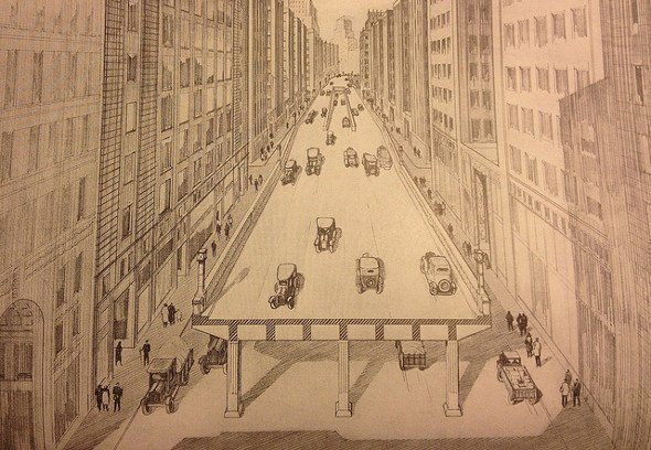
Original conception of the Central Artery (Source).
You know, of course, about I-695 and I-95 in the city - cancelled after residents from Hyde Park to Somerville raised holy hell and the governor canceled the plans and we got the Orange Line instead.
But a 1930 report by the Boston Planning Board (yes, back in the days when Boston had a planning board) proposed a series of new expressways and parkways, pretty much all with the purpose of speeding people downtown - in part through cross-town routes that would take traffic off the major routes downtown.
John McLachlan dug up a copy of the report. It's an interesting report, both to look back and see what was built - and what wasn't.
The key recommendation of the report was what even then they called the Central Artery, running on an elevated platform above Atlantic Avenue. Not only would it speed traffic, it would be far more pleasant than the elevated train track that ran above Atlantic at the time, because, after all, cars were a lot nicer and quieter than those nasty trains. Note the quaint central entrances and exits in the drawing above. And note how it's delicately perched above the existing road, rather than on a massive platform punched through the heart of the city.
City planners felt confident Boston would still need the highway even if all the department stores along Washington Street relocated to the hot new area of Park Square.
In the north, the Artery would hook up with the East Boston tunnel for which the legislature had already approved $16 million. In the south, it would connect with a new Blue Hills Radial Artery - a new road that, like the later I-95 proposal, would require plowing through entire neighborhoods to provide a faster route into and out of downtown, only in this case, on a road to the east of Blue Hill Avenue. The Radial would continue south into the Canterbury Parkway, which would connect Dorchester to Roslindale and West Roxbury, via Franklin Park (the board proposed making up for the loss of parkland by closing the roads in the park), and then the Clarendon Parkway, which would hook up with Washington Street after bisecting Stony Brook Reservation. People seeking alternate route could take the parkways the board wanted built on the Milton side of the Neponset and the Brookline side of the Muddy River.
Then, as now, traffic through Forest Hills was contentious. Planners proposed solving the mess by digging an underpass for the Arborway and Morton Street under Washington Street. Planners also loved the idea of rotaries wherever major roads intersected - Massachusetts was the rotary pioneer, after all - and lots of stone-faced underpasses and overpasses to reduce the number of intersections between major and minor roads.
Of course, we got the Central Artery. And it wasn't quite the thing of beauty planners hoped.

The actual Artery project took up a bit more land than originally planned (old North Station/Garden in upper left). Photo by Leslie Jones.
And while many of the projects in the report never got built, its authors would probably be amazed at what did: Instead of just one tunnel under the harbor, we now have three - and a giant bridge over the Mystic. We never got a Roxbury Crosstown road, but the failed 695 project left us with Melnea Cass Boulevard. There's no below-grade crossing at Forest Hills - but the entire Central Artery is now underground. And they probably would have loved the idea of the Mass. Turnpike extension and the current 128 (back then, 128 was a collection of older byways cobbled together with route markers). One wonders what they would have thought of the elimination of almost all Boston's trolley lines.
The Boston Public Library has posted more than 200 photos of Central Artery construction.
Central Artery photo posted under this Creative Commons license.
Neighborhoods:
Free tagging:
Ad:
Support Universal Hub
Help keep Universal Hub going. If you like what we're up to and want to help out, please consider a (completely non-deductible) contribution.
Comments
Looks like the High Line
In NYC, there still exists what was an elevated railway in Manhattan. It was built to get the trains out of traffic and street life, as there had been many accidents. The structure remained after it was abandoned, and plants started to take it over. This inspired people to have it preserved as a linear landscape.
Now it is an elevated urban oasis that is pleasant to walk on (and, apparently, a foot-commuter superhighway due to there being no need to stop at every street, too). http://www.thehighline.org/
Funny how the first drawing, above, implies that the elevated structure wouldn't shadow the street below, though. There were enough elevated structures in Boston of that time to know better.
The elevated NYC highway that no longer is
The West Side Drive was actually a lot like the artist's conception of the Central Artery at the top. Naturally, the city never did enough maintenance on it, and eventually a hole opened up right under a truck, which promptly crashed to the ground. The city originally planned to replace it with a much larger highway, then abandoned the idea and used the money for subway projects (hmm, that sounds familiar).
If you want to see
some good 1970s views of the elevated West Side Highway, rent Live and Let Die.
IIRC, the collapse that closed the highway for good occurred within a year of the film being shot.
Ayup
I remember it well, because my father's office was roughly two blocks away from the collapse site (and the World Trade Center ...).
My uncle spent nearly his entire
adult life living in the Battery section of Manhattan. He worked in the construction trades most of that time(including a stint as a supervisory diver on the Brooklyn-Battery Tunnel) before he retired and opened a restaurant (Ye Old Dutch Tavern).
Some of my earliest memories of Manhattan are from the time in 1969 that my uncle took me and my father into the World Trade Center site when it was still being constructed.
The Inner Belt
Have you seen the Cambridge Historical Society's lecture series on the Inner Belt? There are videos of all three lectures on their website.
Couple of remnants besides Melnea Cass
The stubby ramp to nowhere off 93 that you can see when you head from Leverett Circle to 93N, which sits above Inner Belt Road.
And let's not forget the mural on the side of MicroCenter on Memorial Drive.
One of these days, I need to hike out to the remains of northern half of what would have been the 128/95 cloverleaf in Canton. Just because.
I'm pretty sure they're
I'm pretty sure they're starting to remove the remnants of the Cloverleaf, and in any case it's been used as an asphalt storage ground for a while now.
I've heard there are remnants in Blue Hills Reservation, though
Yep, via the Blue Hills
That's how I'd get to it. This Google satellite view shows there's a bit more to it than just the DPW building you can see as you do the warning-trucks-tip-over loop from 95 to 128.
Quite a bit more, actually
The road devolves from pavement (most of it covered in a pile of asphalt) and semi-dead equipment to just asphalt, and then graded earth for quite a ways into the woods; the Google Earth view doesn't convey just how far it goes as the canopy on both sides stretches over the road cut, which isn't that wide after it goes into the woods proper-- much less than what would have been the footprint of the road.
Very cool spot, if marred a bit by noise and somewhat weird access. Then again, it's less than 1/10 as crowded as the Hill part of the reservation.
MassDOT has eventual plans to convert
the current NB "suicide ramp" from I-95 north to I-95 (128) north to a left hand flyover configuration.
However, given the study requirements and funding constraints, the project is years, if not decades, away.
It'll still probably get done
It'll still probably get done before the Green Line extension.
Busiest intersection in Massachusetts
The improvement to the I-93 I-95 interchange in Woburn is project 605605, years away, but less money than the Green Line Extension!
As an aside the Project on Route 2 in Lincoln at Crosby's Corner is a swath of destruction after clear cutting many, many trees. Fixing the interchange in Woburn will be larger. BTW, for many years the aborted route 3 widening south of 128 was quite visible...
I just went by that Lincoln spot...
What in the hell are they doing there?
They are converting the Crosby's Corner
intersection to a grade-separated flyover.
So 65 million bucks just to eliminate a red light?
So cars that don't want to go past that turn can access residences on a new side street?
Thank you for explaining that Mural!
I've been trying to figure out that mural for the past 15 years. I just figured it was in opposition to the original I-95 built in the 50's but it seemed like an odd location to protest a road that old. Makes much more sense now. I'm glad they've kept it around.
The connection from I-93 SB
to the "inbound" Leverett Connector, and the connection from the NB COnnector to I-93 NB, were built on the other I-695 stub.
Another remnant...
In Revere there are some stub ramps to nowhere off of Route 1 just north of the exit for Route 60, at the spot where Route 1 narrows down. Those were supposed to carry I-95 north through the Lynn Woods. That was another highway project that Gov. Sargent shot down.
About 20 years ago those ramps became notorious, because delinquent kids would take stolen cars there, put a concrete block on the accelerator, and launch the cars off the end of the ramp into the marsh. Great fun!
(When Route 1 in Lynnfield and Saugus -- the old Newburyport Turnpike -- was widened in the 1930s, the state also built the section of Route 1 that connects from the minigolf with the orange dinosaur to Route 60. They also widened that part of Route 60, and built the part of 1A from Bell Circle to the Sumner Tunnel. That made for a full complement of "improved" roads from the tunnel all the way up to Lynnfield.)
Unlike the Southwest Expressway
and the Inner Belt, the ultimate reason that the extension of I-95 from Revere was never constructed (apart from the embankment across the Lynn Marsh) is because Lynn Woods is the City of Lynn's drinking water supply, and they couldn't find a suitable alignment without going through the Woods.
In hindsight, it's probably a good thing that the proposed I-95 alignment over the Lynn Marsh was never opened to traffic, as the paved section of the embankment partially imploded in the mid-1970s. As I understand it, the failure occured because, although the embankment was designed to accommodate tidal inflows from the ocean, no provisions were made in the design to accommodate the outflows back to the ocean.
The story also goes that, until the embankment was mostly removed to re-sand Revere Beach, one of MIT's Highway Engineering professors would take his classes on a field trip to observe the failure. I've been told he called his field trips "How not to build a highway."
Fascinating!
The report itself is utterly fascinating. It's easier to judge in hindsight, I guess, but take a look at their proposed design for expressways that would carry most of the downtown traffic away from the central artery (page 15, illustrations on 17). No concept of stoplights, so drivers on cross-streets that wanted to cross major roads would have to turn right into oncoming traffic, cut across three lanes of traffic in 150 feet, make a U-turn at the next median strip, and then do the same thing again to get back to the previous side street. All the assumptions were predicated on traffic density assumptions that sound hilariously naive (600 cars per hour! 290 feet between cars, all of which would be studiously traveling at 30 miles per hour!), and the pedestrian considerations could be charitably described as "Frogger 40 years before arcade games existed."
I'm only partway through this, but it's really captivating. Thanks for posting!
Really fascinating document
The best part about those Express Roads they have detailed are the four parking spaces that would exist in the space between U-Turns. It looks like four spaces, with barely any space to get out of your car and ZERO provisions for drivers to get to/from their parked cars across the express way.
http://archive.org/stream/reportonthorough00bost#p...
ZERO provisions for drivers
Whattaya mean, "provisions"? It's Boston. You cross the street when you want to cross the street. What's the problem?
Goes back further
I think you can dig up copies of their reports back to 1915 or so.
They were absolutely obsessed with road widening. It seems like every other proposal was to knock down a block of buildings to widen some street or another. Even a strip of the Public Garden was taken to widen Boylston Street.
After the advent of the automobile and prior to complete streets
We have to tear down the city and turn it into nowhere to widen or build the roads so that people can drive to the somewhere which no longer exists!
Engineers
Which is why it's important for engineers to get a well rounded Liberal Arts education. So they have at least a slight understanding of the society they have devoted themselves to serving.
Why does it feel like you're
Why does it feel like you're making a dig at engineers? Engineers with or even without taking Liberal Art classes have an understanding of society. But even the most knowledgeable makes mistakes. Robert Moses was a Political Science major with a huge sense of civic duty, and it didn't stop him from his misunderstandings.
Liberal Arts has it place (and strongly more in the historic sense when it mean studying the great books with emphasis on logic and rhetoric than the more muddled state today), but I feel citing the lack of liberal art education in engineers is more a dig at engineers and its stereotypes than a real insight.
College majors most likely to work retail
The top one is reportedly anthropology. Sociology is up there too.
Got a citation for that?
I've got two headed to college in the next three years, so I'm interested in these things.
Also, consider that the number of children in the population is growing due to folks moving in and living the American dream, but something like 50% of the teaching workforce is set to retire in the next 5-10 years.
So, if people are bullied away from liberal arts majors or fed horror stories without factual support, who is going to teach the next generation of engineers how to formulate a proper sentence?
Some citations, more exist
I found this local article, but there was another somewhere that also included percentage of major now working retail. Worse on this one than anthropology is architecture, which must be really crushing for those grads considering how hard they work for that degree.
http://www.boston.com/yourtown/2013/06/26/what-col...
It is based on this report:
http://www9.georgetown.edu/grad/gppi/hpi/cew/pdfs/...
Education has good prospects for getting a job. Engineering and computers pay better. Good education values are state schools and those in Canada.
Let me add my own anecdote and link to Mark's link
Though I have a link that seems to really fit Mark's initial comment than the boston.com one (Anthropology as first). I'm guess it to be the difference between 2012 and 2013.
http://www.kiplinger.com/slideshow/college/T012-S0...
----
That said, with a sample out of my friends and myself, 2 years out from graduating from BU we seem to be various spots. My fellow CS majors seem to be gainfully employed. I know a number of people in School of Management and the results are mixed but moving up (including one being most successful of my circles, but others working in payroll or selling cell phones, but recently got better and fitting jobs). I have a couple of friends who majored in the medicine area, those who are in research are thus working their field but getting paid quite low versus their knowledge and level of study I seen, the rest are moving on to med school.
For people in the Liberal Arts (checking from recent direct interaction, but also Facebook and LinkedIn), they are mixed. I have to notice many some are doing cool things. Like one is in Egypt and another is somewhere in Africa to help good causes. A bunch of people majored in International Relations. The most impressive one is working in a non-profit in DC on Public Policy (she graduated with top grades... but I also have to note her parents have a Wikipedia page). While others are more tame like a store manager of a UPS or program manager at a non-profit. One friend majored in IR and Religion with a minor in Arabic and now been recently hired to work for Liberty Mutual (though he just returned from a year teaching English).
I have to admit this post would be incomplete without one sticking out in my mind. I have one friend who majored in Anthropology... He has been making a lot Facebook Status posts decrying his lack of a job. Though I also want to also note he was able to join an archeological dig in China for a month, but it seems he's back in Boston and making statuses on his job search again.
Though unlike the linked article and no matter how many friends I can check up, they are still anecdotal. So grain of salt and everything. But there has to be some truth in it.
----
In regard to your last paragraph, currently it seems we are graduating plenty of students who devoted completely to Liberal Arts. It is unlikely that many would be pushed away to cause a true shortage. Though putting all to engineering won’t help either. Contrary to claims by companies, everyone majoring in Engineering isn’t going to create more positions in the field.
Activities most likely to kill you in the next 24 hours.....
1. Playing Russian Roultette.
2. Driving a car.
Oh no!
Undergrad majors don't really mean much anyway, unless you want some real specific job, or be a Doctor (probably need more science classes).
This persisted into the
This persisted into the second half of the 20th century. The MDC wanted to chop down sycamores on Mem Drive to make pedestrian underpasses. From the 1964 Harvard Crimson:
Velluci was then a city councilman, he later became mayor of Cambridge. A protest movement came up to defend the trees; eventually the plan was dropped.
Even later than that
Back when the Natick Mall and Shoppers World were both planning to become mega-malls, state officials floated a plan to double-deck Rte. 9 from Speen Street to just past the malls and to create pedestrian underpasses to satisfy the cranks who insisted that area needed to be made more pedestrian friendly.
Same Vellucci?
Who staunchly defended trees planted to obscure the Harvard Lampoon building? Gee. Sounds totally sincere in his arbor amore.
(also father of the fictitious "Nipples Vellucci" no doubt)
Agree - excellent post
Such a wealth of historical information here. Thanks!
Ruggles and (Columbus and Tremont) to Jackson Square was raised
while "residents from Hyde Park to Somerville raised holy hell and the governor" [Sargent]. Sargent declared we were not going to "bulldoze the cities." A tad late for that Governor! Northeastern made lots of lemonade from that. Place to put a snow farm. Build a high rise garage. Or have Quincy do its utmost to get the RMV HQ located in Quincy. RMV HQ was built, abandoned as a sick(indoor pollution) building.
Yes, you're right, didn't mean to gloss over what was torn down
And 40 years later, the parts of Jackson Square that were torn down are only now getting rebuilt - or at least, that one big building on the corner of Columbus Ave.
There were bits of the right of way that were torn down in other places as well. Drive north on Cummins Highway from Hyde Park Avenue in Roslindale and just after the bridge over the train tracks you'll see a community garden on your right. That used to be a couple of blocks' worth of houses, torn down for the I-95/Cummins Highway interchange that was, of course, never built (the MBTA might actually still own that land).
Before Sargent became Governor of Massachusetts
he was Commissioner of the Massachusetts Department of Public Works - now MassDOT Highway Division, which was the agency charged with construction of I-95 and I-695.
Talk about a textbook political "flip-flop".
razed.
razed.
If you want some other
If you want some other bizarre abandoned traffic planning fun. Look up the beltway that was supposed to go around Hartford. There are a bunch of screwed up elevated construction things that remain around there to this day and lots of dead end highways (like CT Route 9 I believe).
Also there were almost set in stone plans for a bridge across Long Island Sound to New Haven, I think, which explains why NH is awful for traffic. If you follow across the sound on google maps (satellite) you can see where a once highway terminates right by the water, built in preparation for the bridge.
Weird wild stuff.
CT
Was highway crazy in the 1950s..
here's a mockup that someone did.. courtesy of Kurumi.com
http://www.kurumi.com/roads/ct/pics/art-hfd-fwy-60...
Here's the gigantic triple
Here's the gigantic triple overpass west of Hartford on I-84 that's mostly unused: http://goo.gl/maps/b1DYn
Yep, that's the one. Complete
Yep, that's the one. Complete mess. Fun to drive around and explore, though. In 2006 or so there were gigantic elevated highway segments still somewhere southeast of Hartford. Sooo much money wasted.
Seven high stack?
I remember my dad, a road builder, insisting that we go a certain route down I-84 from Boston to Washington DC just so we could see this six- or seven-high stack of highways that used to cross just past Hartford going Westbound.
I didn't notice it the last time I drove through there, but it was dark. Still around?
UPDATE: Here it is - between Hartford and Waterbury: https://ssl.panoramio.com/photo/55453786
At least one of the lanes has been hooked up
The last time we drove through it, there was traffic going over one of the lanes. Unless we were seeing ghost cars :-).
It's only four high, counting
It's only four high, counting the surface road. One of the upper roadways is in use to connect to Route 9 to the south. The rest are ghosts and you can see chain-link fences on the lowest overpass to keep people from walking or biking on it.
Thanks for posting
Thanks for posting that link. I've driving under that on I-84 about 1000 times and had no idea how useless and stupid that was. I've often wondered why they had to build a triple overpass right there of all places.
Even from the street view you can see see all the sections which are dead and never used. Amazing. To think the country used to have so much money for pointless highways like that and now we can't even repave roads.
its Connecticut
My family is from CT.. they remember the 1950s boom in CT as well. Lots of $ in CT at that time and grand plans for roads in CT. They wanted them to crisscross the state, but Most were never built.
To be honest, as much as I love Boston's road/transit history, it's nothing compared to all the cancelled roads in Connecticut.
Read: http://www.kurumi.com/roads/ct/
It has a lot of stuff about CT Roads and the history behind them.
"To think the country used to
"To think the country used to have so much money for pointless highways like that and now we can't even repave roads."
Well that was during the postwar boom when the country had no international competitors in industry left standing. It was also before the budget got hideously bloated with debt service and the massive increase in the size of the government with the exponential growth of the welfare state. The government's biggest expenditure once was infrastructure followed by defense. Now its services+debt, then defense, and infrastructure. The country still has tons of money which is paying for things other than infrastructure.
Anybody seen if the BPL has
Anybody seen if the BPL has photos of the area around the current Orange Line tracks, both before and during construction of the new right of way? I've seen plenty of photos of the old Washington Street Elevated, but would like to see what happened when they cleared (and in some cases, decked over) the current Orange Line/Southwest Corridor. Looking through the BPL sets on flickr, nothing obvious jumped out at me.
Check elsewhere
The George Sanborn Transportation Library has photos of exactly what you're looking for. However, they're shelves in boxes which aren't terribly well organized. If you have the time, it's worth digging around. You'll be pleased even if you don't find what you went for.
Thanks for the pointer! Do
Thanks for the pointer! Do you know if they let you scan/photocopy the images? Or if they're open on weekends?
Some SWC Pix...
...digitized and downloadable can be found here: http://archive.org/details/1980sPhotographsGreenSt...
Nice mix of street scenes and construction.
Old picture of Southwest corridor from 76.
http://cache.boston.com/bonzai-fba/Third_Party_Pho...
That looks like the
That looks like the footbridge I used to cross with my Dad to get from his apartment in the South End to the Prudential, back when I was but a wee lad.
Two BU Bridges?
There is an aerial photo showing existing conditions on page xii or PDF page 18. Why does it look like there are two BU (a.k.a. Cottage Farm) Bridges? To the east of the BU Bridge, it almost looks like a Park Drive/St. Marys Street Bridge to Vassar Street in Cambridge.
There were two bridges. The
There were two bridges. The 2nd one connected to Vassar Street from St. Marys. Hence why that street is so wide and kinks towards the Charles at the very end.
Temporary bridge
Some kind of pontoon bridge was put up when the Cottage Farm bridge was being built. It connected to a street which was later closed and turned into Marsh Plaza.
I have this book too
I have a physical copy. My stepmother worked for the BRA in the 60's and must have got it that way. I'll check to see if mine is 1930 but I'm pretty sure it is.
Lomasney Way
What is the story of that single townhouse (it may actually be on Cotting St. where it turns into Lomasney way)? Any ideas how that was spared the wrecking ball? Stories? Rumors?
Langone would be a good start for a historical fussbudget.
Langone [Boston City Councilor Joseph Langone, III] or the family had a Joseph Langone Jr Funeral home where the (Sen) Brooke Court House(Judiciary Courts) is now. The Hurley Bldg and the Lindeman center is what got built but there was to be a tower. Ashburton Place, JFK Bldg size tower never started.
Merrimac street was to become a boulevard. To continue Congress street west under Gov't Ctr Garage. Langone Funeral Home blocks that. Langone died very quietly as he planned and wanted it.
That West End remnant(Martha Rd -- 42 Lomasney Way) might be part of his legacy.
William Kazonis transferred it to Paul F. Murphy of Yensamol Realty Trust on 9/6/2001. Happy hunting.
Dracula is to alucarD as Lomasney is to yensamoL
Yensamol Realty Trust apparently exists as an eponymous/tautology...as the dog chases its tail.
Lomasney Way research suggestion
For the townhouse that Swirly's asking about, I recall the Globe running a piece about it maybe 10 or 15 years ago. If you have access to their archives, you could try looking it up. That side of the street was never part of any urban renewal projects. Various owners tore down their buildings to create parking lots, but the owner of that building never did.
So much from so many other posts in this
1. Just think, if they only put that tunnel in at Forest Hills, a lot of people would be happy (except, of course, the likes of me who for some reason actually enjoy the Casey Overpass)
2. The odd jog of American Legion Highway in Roslindale/Hyde Park owes it's origin to this report. The Clarendon Parkway would have been one steep road, so I am glad that got shelved.
Great reading!
Neptune Road
OK I actually had time now to READ some of this document.. I love this section tho.. (remember this is 1930..)
PROJECT 52. EXTENSION OF NEPTUNE ROAD
Neptune Road, which now extends as a park boulevard from Bennington Street to World War Memorial Park, should be extended as a parkway near the present shore line to Belle Isle Inlet and the Winthrop Bridge.
Plans for this shore parkway have been prepared by the Boston Park Department and an Act to authorize its construction by the Metropolitan District Commission has been introduced on the petition of the Mayor of Boston. This project has been included in the first construction period.
Well its obvious it was never done because by the 1950's that whole neighborhood went byebye as Logan was expanded.
I just chuckle at this because in 1930 they didnt know logan was going to expand as big as it did and take over the whole Neptune Road neighborhood.
Origins back in the 1890s!
The concept of the Central Artery, or at least its route, go back to the 1890s, and maybe earlier. Here's an 1892 report to the Mass. legislature that proposes, on page 51, a "New Street for Teams" that almost exactly follows the Central Artery route from Causeway Street through to South Station:
http://books.google.com/books?id=besqAAAAYAAJ
While this report does talk about a few new streets, and some widened ones, its main focus was on railroads and transit. This was the report that recommended the consolidation of four railroad stations into one South Station, and it also called for the construction of a rapid transit system, all on elevated lines.
Cool
Thanks for the link - I have such transit reports, but never seen road reports.
Here's an article from 1930
Here's an article from 1930 discussing plans for a raised artery through Boston:
http://goodoldboston.blogspot.com/2012/04/streets-...