Hey, there! Log in / Register

The lyric little bandbox has actually changed quite a bit
By adamg on Mon, 04/13/2015 - 11:47am
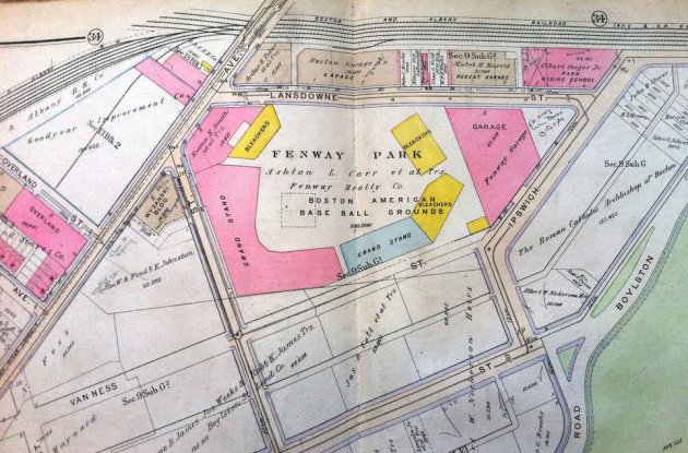
The BAC Library posted a copy of the Fenway map from the 1917 Bromley atlast of Boston.
Neighborhoods:
Free tagging:
Ad:
Support Universal Hub
Help keep Universal Hub going. If you like what we're up to and want to help out, please consider a (completely non-deductible) contribution.
Comments
where's the Wall?
Fenway has had a left-field wall on Lansdowne Street ever since it opened, but this map doesn't show it.
It's a Bromley Atlas that
It's a Bromley Atlas that shows the layout of the city and land parcels, it's not an exact schematic of Fenway Park or any other building.
Does the nearby rail line track carry passengers these days?...
a) Does the nearby rail line track carry passengers these days?...
b) At what point exactly does the Muddy River connect to the Charles River?
answers to questions
a) yes, quite a few. Look up "Yawkey Station". Also, that branch leading off to the southwest is no longer connected to the main Boston & Albany line, and is instead now the Green Line "D" branch.
b) at Charlesgate
Question B harder than Question A
I was running along the Charles about a month ago. You don't really notice the Muddy River when you pass over it. You'd have to be conscious about it's existence to even think about it. I would say the Muddy meets the Charles due north of Charlesgate West. And before the anti-Storrow Drive folk come out, they could daylight the last part of the Muddy and keep the on/offramps the same.
As for question 1, yeah, the T could give you some info on that.
Muddy doesn't
Meet the Charles any more. It dead-ends in a mucky mess under the Bowker Overpass. It hasn't met the Charles since they built the Charles River Dam.
Er, I hate to correct you
But the water has to flow somewhere. Some rivers (like the Colorado) go dry when too much water is drawn from it for irrigation, drinking, or whatnot. That doesn't happen with the Muddy.
Remember, they are daylighting the river at the Landmark Center over flooding concerns.
That's not true
Want proof? There's a herring run in the Muddy every year in the spring. If you go to the Fens you can see it -- so many herring they make the surface of the water swirl. It's pretty cool. I think the waters have to still warm up a bit, but it should be pretty soon.
The Muddy River is not the Millers River
The Muddy is several miles from the dam, and drains into the Charles at Charlesgate.
It is the single biggest source of pollution into the Charles these days, due to a Combined Sewage Overflow (CSO). Even so, it is way better than it was in the mid-80s, when it would smell like an open sewer and you could see the plume into the Charles after a rain.
The Millers River has been heavily filled and no longer reaches the Charles. It is spanned by the bike/pedestrian bridge under the Zakim.
Canal?... where MassAv, Main St, Columbia St meet in Cambridge.
Was there once a canal?... Is there still a canal?... under where Massachusetts Avenue, Main Street, Columbia Street meet in Cambridge.
Here Don
Here are some older maps of Cambridge. The last one has a good representation of the canals over by wards 1 and 2.
That reminds me. Does anyone know when the last time was that Cambridge changed the boundaries of their wards and precincts? Are there any good maps available that show the current boundaries?
The Muddy River no longer has
The Muddy River no longer has any combined sewer overflow connections. Brookline was brought kicking and screaming into compliance by the Feds to fix their dumping into the river.
Is there a culvert?... for the Muddy River to the Charles.
Is there a culvert?... for the Muddy River to the Charles.
Exactly
Though you would probably have to be on a boat on the Charles by the outlet to get a full idea of what it looks like. For the record, I have not seen it.
Just walk along the Charles -
Just walk along the Charles - I've fished for carp at the outflow.
However
Have you "seen" the outflow?
To be fair to me, I went by the outflow when the Muddy, the Charles, and the rest of New England was frozen solid. I'm sure that if I went by again today, I'd get a better idea of where it is.
HOORAY!
Good! I hadn't heard about that - I knew there were lawsuits in the works to stop it.
Belmont had similar kicking and screaming episodes about sewer leaks and discharges, and finally got the hammer dropped on them about the levels of e-coli in the brook running through town.
I gotta disagree with you
Even the Wikipedia article you reference notes that it runs into the Charles, or at least the tiny part that is left. Hence the spanning of the river under the Zakim.
All rivers, streams, kills, brooks, whatevers begin and end somewhere. Usually they end at some other water feature.
The Muddy River has red-eared slider turtles
The red-eared slider (Trachemys scripta elegans) is turtle of the Mississippi valley, but it has invaded both the Muddy River and the Charles. It seems to be able to survive our harsh winters just fine. I've yet to see the native eastern painted turtle (Chrysemys picta picta) in the Muddy River; the invaders may have displaced it.
at charlesgate
at charlesgate
At last!
I'm glad we finally got to see this map atlast.
Wardmaps.com
They have a HUGE collection of Bromley atlases available to look at on line.
It's a fascinating way to study where the streets used to be in Boston.
before the BRA started
before the BRA started mucking with things
What year was most recent change to any Boston Ward or Precinct?
What year was the most recent change to any Boundary of any Boston Ward or Precinct?
It doesn't confirm/rule out a more recent change to a Boundary of a Ward or Precinct. even though 1969 is listed at
https://bpl.bibliocommons.com/item/show/4531798075_voting_precincts
see also
Boston Wards and Precincts
http://bostonwardsprecincts.blogspot.com
Interesting side note
Those colors tell you the main construction material of the structure. Insurance companies used to use these to underwrite property insurance. I'm guessing the red was brick - and the original is still in place. The yellow here for the bleachers was probably wood - because I believe those left field bleachers eventually caught fire and burned despite repeated warnings from city inspections to tear out the wood bleachers and install masonry.
Two big fires at Fenway Park
in 1926 and again, more seriously, in 1934. More info here
Boston Beaneaters
Baseball and fire have a history in Boston.
There were some very good reasons why wooden stands were not a good idea from the get to at Fenway. In 1894, a fire started at the South End Grounds during a Beaneaters game and spread in to the surrounding neighborhoods.: http://goodoldboston.blogspot.com/2013/03/the-great-roxbury-fire-of-1894...