Hey, there! Log in / Register

Where's the village smithy?
By adamg on Mon, 02/09/2015 - 10:27am
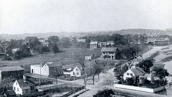
The folks at the Boston City Archives wonder if you can place this bucolic scene in old Boston. See it larger.
Neighborhoods:
Topics:
Ad:
Support Universal Hub
Help keep Universal Hub going. If you like what we're up to and want to help out, please consider a (completely non-deductible) contribution.
Comments
Peabody Square
Peabody Square
Brighton with Newton
Brighton with Newton highlands in background.
Dorchester?
Dorchester?
looking up Freeport street toward Dorchester Ave with St. Peter's Church in the back right?
The village smithy
Under a spreading chestnut tree, of course (although I can't tell if there's a chestnut tree in this picture).
The photo was taken at elevation
Hill? Church? Tower? Balloon?
Maybe to the west of the city given the hills behind.
This was taken on top of a
This was taken on top of a snow pile. Why did they get plowed?
Old Boston
That is gorgeous!
Commercial Point
Might this be a photo taken from the top of the old gas tank, well before Corita painting Ho Chi Mihn along Freeport Street in Dorchester, looking northwesterly towards Meeting House Hill?
That looks like St. Peter's off to the right and the hill fits the profile of the now Ronan Park.
The giveaway is the tidal water in the right of the photo, which is now under the expressway.
This photo is probably about 1885. The pre-cursor to Boston Gas started buying up a lot of the houses in the area in order to expand their land for bigger tanks.
Just a guess.
This is it
You're definitely right. I took a screengrab of the 1894 Bromley atlas, which is as far back as that section of Dorchester goes on the BRA map site. The intersection in the foreground is Union/Freeport/Neponset. Dorchester Yacht Club would be on the upper right just out of the picture.
I was
wondering since it looks like shoreline to the right of the photo! I also thought perhaps East Boston if not Dorchester.
Picture
Hyde Park
Cottage Farm? (Near current
Cottage Farm? (Near current BU Bridge, formerly called the Cottage Farm Bridge.)
Jamaica Pond
It looks like water to the right, with a building that might be an ice house.
Look! Look at all that not snow!
*sigh*
I second the guess that this is Dot, looking at the current site of the Savin Hill Yacht Club.
Hmm - Don't recognize
I don't recognize this as being somewhere in Boston b/c I don't see 5 feet of snow everywhere.
Here's what I wonder
Did the fine Boston City Archives really trek out to the Siberian wilderness that is Rivermore Street today?
My out of nowhere guess is East Boston. Orient Heights.
Ah, the beauty of VPN.
Ah, the beauty of VPN.
We are not at Rivermoor today
We are not at Rivermoor today, but we are working from home. :)
The Answer!
Thanks for playing, folks! This is the junction of Commercial, Union, and Neponset Streets in Dorchester. The date is circa 1888.
Had to look this one up...
Commercial Street was renamed Freeport Street in 1892. The road was relocated when the Southeast Expressway was built, and would have been right about in the middle of the present highway. Neponset Street (not the Avenue) and Union Street were short, old roadways serving a residential neighborhood in the Commercial Point area, all of which has since been taken over by Boston Gas or National Grid or whatever they're called now. The photo was probably taken from the top of a gas tank — yes, there were even gas tanks there in 1888, at least according to a Bromley atlas from a few years later (1894).