Hey, there! Log in / Register

Time for our annual copter-based pre-Marathon background-radiation checkup
By adamg on Fri, 04/07/2017 - 10:42pm
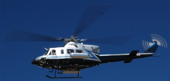
Radiation-checking helicopter.
The National Nuclear Security Administration alerts us that it has a helicopter flitting around the Boston area this weekend taking readings on background radiation in the area in advance of the Boston Marathon:
So if you see a white helicopter with blue stripes flying relatively low to the ground (about 150 feet), that's probably them:
Officials from NNSA announced that the radiation assessment will cover approximately 13 square miles. A twin-engine Bell 412 helicopter, operated by the NNSA Remote Sensing Laboratory Aerial Measuring System from Joint Base Andrews, will be equipped with radiation sensing technology. The helicopter will fly in a grid pattern over the area at 150 feet (or higher) above the ground surface, at a speed of approximately 80 miles per hour. Flyovers will occur only during daylight hours and are estimated to take about two days to complete.
Neighborhoods:
Free tagging:
Ad:
Support Universal Hub
Help keep Universal Hub going. If you like what we're up to and want to help out, please consider a (completely non-deductible) contribution.
Comments
What about checking the
What about checking the radiation continuously for the people who live here???
already done
What you are asking for is already being done.
There are static sensors in various places run by multiple agencies that alert if a local spike is seen. Every once in a while you see the chaos caused by someone who recently had radioactive cancer treatment -- if they walk or wander through the wrong space they set off all sorts of reactions.
Hell the MBTA tunnels and platforms are now studded with strange sensors with the only public sign being the occasional tests they do to model airflow and dispersal as they release taggants and test gasses.
The helicopter has nothing to do with proactive protection. They are trying to update a "before" map model just in case something happens. Glad to see it being done although I would really prefer that they never, ever have to come back to do an "AFTER" map modeling run ...
How confident are you that
How confident are you that this is a baseline for an After map, and not a During map? I figure they'll rescan just before and during the marathon so they can see if someone has moved radioactive materials in.
(What a farce, in any event.)
could be wrong ...
... but I think this has nothing to do with "active" protection like being able to detect someone moving something in. This is all about making a post-radiation aka dirty-bomb event response safer and better rolled out.
Trying to find the original citation I read but I think the whole point of the helicopter is that the US (NSRC, NERT, FEMA, whatever ... ) already has a pretty rigid SOP for responding to radiation events. In an "AFTER" situation they would run the copter again to generate the "AFTER" map. If they compare that to the BEFORE map and run it through a model that is aware of time, wind, weather etc. then they would be able to see the new radiation "spread" (speed, direction, size of zone, etc.) and base decisions off of that. The "before" map is simply used to erase known radiation spots so that their model is mainly tracking the new contaminants.
Then that data is used to (a) figure out who/what/where needs to evacuate and (b) where to stage the responders and gear so that they are not in the path of a plume.
Yeah, a farce. Until God
Yeah, a farce. Until God forbid some douche detonates a dirty bomb, then you'd be criticizing the lack of planning, preparedness, etc.
My eyes!
The goggles do nothing!
It's an old u. But the red
It's an old u. But the red and white on its blades is impressive