Hey, there! Log in / Register

Once, thundering herds of trolleys roamed Cambridge
By adamg on Fri, 08/26/2016 - 10:46am
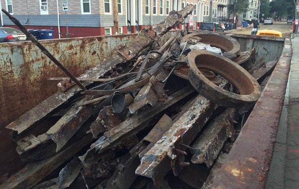
Ari Ofsevit has been watching workers rip old trolley tracks out from under Pearl Street in Cambridge as part of rebuilding the street. He shows us some of the tracks, last used around 1925. Also, he got a souvenir brick.
Neighborhoods:
Topics:
Ad:
Support Universal Hub
Help keep Universal Hub going. If you like what we're up to and want to help out, please consider a (completely non-deductible) contribution.
Comments
So sad
The remains of an an excellent (or at least better) transportation system from the distant past. At this point few are alive to remember when you could take a trolly to get to almost every neighborhood in metro Boston and private car ownership was rare.
Now we're looking at several billion just to extend a single line a few miles down mostly existing ROW. Sad!
I know...
I was amazed when I first learned how extensive the trolley system was in the area and bewildered about how this could have all been given up.
It's simple
Buses are more nimble and automobiles can take people where they want to go when they want to go there.
I'm a big fan of public transportation, and I love trolleys, but I also know and understand history. Trolleys were the print media of their era- ubiquitous, then obsolete, with a great cost to the public in the long run.
Buses are so much better than trolleys...
The 66 and 39 buses are so nimble they manage to hump each other in an orgy of 6 way, bumper to bumper, bus love. Then you wait 60 minutes for the next one.
I take it you never took the E line
At least out to Arborway. And yes, I'd love it to be restored, but if you think putting vehicles on rails in mixed traffic would resolve the issues faced by the 39, 66, 28, or most other bus lines, I've got a bridge to sell you.
Electric Railway map 1913
Look how much of the state and region you could get to by electric mass transit!
Destroyed with the long game, both physically and psychologically, by oil and car companies.
[img src="https://upload.wikimedia.org/wikipedia/commons/d/db/1910_Tri-state_Troll..." alt="https://upload.wikimedia.org/wikipedia/commons/d/db/1910_Tri-state_Troll..."]
let me fix that for you
The Biggest Drop In The Bucket...
And that just shows the trackage of a single company! The Bay State Street Railway was the largest system to ever operate in New England (and the entire US, if I am not mistaken). At that time you could ride as far west as Westfield and Woronoco via Worcester, Palmer and Springfield; to Greenfield via Fitchburg, Athol and Orange; and even make your way down to Hartford, New Haven and New York City! One street railway guidebook of that era even gave directions, timetables and fares for streetcar trips from Boston to Maine. Of course, such long distance trips were literal day trips. And remember to bring along a sock full of nickles!
As I noted in a similar thread, while autos did have a major impact on streetcar systems, the fact that many of the large Massachusetts interurban systems ran through sparsely settled territory didn't help matters. Buses proved to be a stopgap measure to preserve service on intercity routes and provided a cheaper alternative on low ridership urban routes. Buses also allowed service to be provided to new territory (i.e. how the modern Route 38 got started) without having to ask the cities and towns for locations in the streets and then spend money on track/overhead for a line that may just get discontinued several months or years later.
Amazingly, a few interurban public transit options still exist. Via MBTA Commuter Rail, MART and the FRTA one can travel from Boston to Northampton. (A semi-regular pilgrimage I actually make to visit The Finn, The Countess and other friends along the Connecticut River valley; plus get some fan trip mileage on the Gilligs, Internationals and Mini Xcelsiors.)
The highly-experimental and somewhat obscure MAX (http://ridemaxbus.com/) allows for a one-transfer trip from Boston to Gardner, Athol, Orange, New Salem (!!!), Pelham, Amherst and Northampton. And you get to ride a brand new, totally tricked out MCI D4500!
If travelling on a weekday and feeling especially adventurous, you can also take WRTA Route 33 to Brookfield, bike to Belchertown and connect to PVTA Route 45. But if you love flying downhill along country roads at ~40 m.p.h. as much as I do, just keep biking past Belchertown to the Norwottuck Rail Trail and connect to PVTA Route 43 in downtown Amherst.
The MVRTA and LRTA connect the Merrimack Valley rather well from Newburyport to Tyngsborough. GATRA, whilst not a monster Godzilla ever fought, does a decent job of connecting Attleboro, Taunton and the towns surrounding.
Black and red lines are all electric
trolley routes on this map. Steam trains routes are also on the map.
Goto the main link for the big-sized picture, you'll see the detail. So amazing!
(Thanks for the correction!)
Trolleys today are like the buggy whip
in 1920....well pass due. I don't care how modern they are, they should have been retired by now. The green line is most definitely the weak link of the MBTA subway system,painfully slow, chronically lacking capacity, etc.
Only because the T doesn't lknow how to manage them
Light rail (which most of the T system basically is) in other cities has three-car trains, signal priority and all-door boarding, and is fast and efficient. The T, on the other hand, is basically okay with operating its trains as slow as they can.
brookline st.
they pulled up the matching set from brookline street when it was redone around five years ago. the trolley barn was on brookline.