Hey, there! Log in / Register

Before Government Center
By adamg on Thu, 07/23/2015 - 10:49am
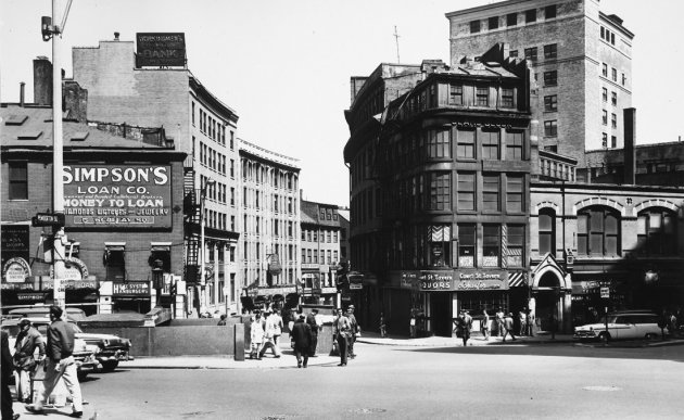
Where City Hall didn't used to be. See it larger.
Between 1954 and 1959, urban planner Kevin Lynch took hundreds of photos in Boston and Cambridge to help show how residents build up a sort of mental map of what their city is like. The MIT Libraries have posted 1,900 of his photos. He seemed particularly interested in Copley Square, where he took photos every 50 feet, but you'll also find plenty of photos of other parts of Boston and Cambridge, including Scollay Square in the years before its destruction (in the photo above, imagine you're standing in front of Center Plaza - which wasn't there - and looking down Cornhill Street, where City Hall and the glass tower of the T stop are now on the left, and what is now the Sears Crescent appendage to a more modern building on the right).
Kevin Lynch and the Imageable Boston.
Photo posted under this Creative Commons license. H/t Jared.
Neighborhoods:
Topics:
Free tagging:
Ad:
Support Universal Hub
Help keep Universal Hub going. If you like what we're up to and want to help out, please consider a (completely non-deductible) contribution.
Comments
wow...
...what we lost.
But
We've gained a lot too. More infill, more people in the core. Downtown was a fairly sad place well into the 80's. What he omits is a lot of the downside, a lot of vacant upper floors, accomplished through disinterest in the city and really crappy taxes.
I like looking at these but I will take Boston today over the 1950's any day.
None of that necessitated
None of that necessitated bulldozing an entire neighborhood. They were about to do the same thing to the North End, which was in a similar state at the time. Now look at the North End today. John Collins was just playing into the interest of developers and the upper class who wanted that property. Don't think it was to do the city any favors, despite what the area may be like today.
I hear ya but...
I just think Boston coulda been a more interesting place had we preserved more. "Save the South End:: i remember those signs, and you know what? we did. (other than the fact that it just a playground for wealthy people in red shorts, flip flops, and little puffy pooches named Fifi or Nacho)
Wow, I could sit all day
Wow, I could sit all day browsing these old photos. I look for familiar faces of older family members possibly caught in some candid shot. I also remember some old signs that are long gone.
(A friend told me once he saw a candid picture of my father at a recruitment station in Boston signing up for the Navy after Pearl Harbor - so it is possible)
No one complains about the loss of the large rail yard
This was such a large hole in the city.
Why didn't city hall plaza go there?
It would have involved far less destruction.
Because Mayor Collins was a
Because Mayor Collins was a scumbag. I wish someone would take down his picture from outside City Hall. There's no honor in destroying parts of a city that would be thriving today.
WOW
trinty park smaller you could park in front of trinity church i remember the
newspaper stand at the green line late 80s guy was very old. not many remember
that far back prince spaghetti house avery hotel blows your mind wow
Sears Block
Is still there, albeit with a giant teapot hanging from it
Given how popular (and
Given how popular (and expensive) the North End is today, the West End probably would have been the same way. I bet some regret its destruction now. Instead of a thriving neighborhood we just what is the worst use of urban space in existence. Good job Boston.
"He seemed particularly
"He seemed particularly interested in Copley Square, where he took photos every 50 feet, ..."
The original Google street view...