Hey, there! Log in / Register

It's never good to run aground on Nix's Mate, but at least they don't gibbet sailors there anymore
By adamg on Sun, 09/27/2015 - 6:54pm
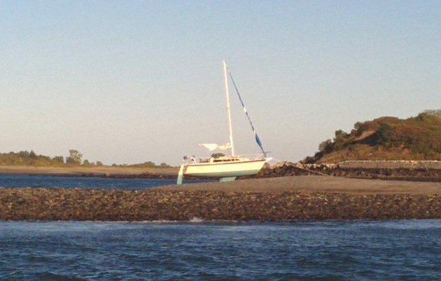
Out in Boston Harbor today, Ryan Meador noticed two boats that had run aground - the first on Nix's Mate, a little nothing of an island on which colonial authorities once gibbetted the bodies of executed pirates - they hung their bodies up to sway in the wind as a warning - the second in an area called Lower Middle.
The first boat appeared pretty solidly stuck, but the second looked like it might make it off when the tide came in:

If there's any consolation to the sailors of the two boats, it might be that captains of far larger craft have also gotten stuck on Nix's Mate.
Free tagging:
Ad:
Support Universal Hub
Help keep Universal Hub going. If you like what we're up to and want to help out, please consider a (completely non-deductible) contribution.
Comments
Isn't there a light on top of Nix's Mate?
It's not big enough to be called a lighthouse, but *something* is there to mark it so boats can avoid it.
Nixes Mate is unlit
Nixes Mate is unlit
There are clear routes marked
There are clear routes marked well outside Nixies by lighted and sounded government bouy but the Westerly is designed with twin keels to sit nicely when the tide goes out. There's an anchor line if you look closely. Just takes patience, the tide is back in 5-6 hours.
Nix's Mate
is not in this picture.
Huh
Do you know what that is then?
It probably is Nixes Mate, or the shoal surrounding it
Nixes Mate is a black and white stone tower atop a stone base on a rocky shoal that is submerged at low tide. To the uninformed, it appears that you might be able to sail quite close to it, but the chart clearly indicates otherwise
They're referring to Nix's
They're referring to Nix's Mate, not Nixes Mate, mate.
Actually, it's either
Both Nix's and Nixes are used in charts and publications.
Nixes Mate
On the NOAA chart, i.e. the official US government chart, it is Nixes Mate. So that's the official name. End of discussion.
It is Nix's Mate
There is the black and white pyramid what people refer to as Nix's Mate but there is also the spot of land on which Nix's Mate, the pyramid is on, which is what this boat is stuck on.
Boats get stuck there a lot. Let me correct that. Idiots who cannot read a chart and tell time versus a tidal chart get their boats stuck on this piece of tidal land a lot.
This is the nautical equivalent of driving through a storefront window.
The people stuck on these boats have to wait out the tide of call SeaTow. They also get a fresh amount of giggling from the Hingham Ferry as it sails by in the marked channel.
http://www.charts.noaa.gov/OnLineViewer/13270.shtml
The first boat is indeed on
The first boat is indeed on Nix's mate. Here's another photo I took of it that makes it clear:
The second one is actually on Lower Middle, which is a shallow spot about 2 miles closer to Boston from Nix's mate. I heard on the VHF that the state police took the crew off the second boat.
Thank you for these photos. I
Thank you for these photos. I read about Nix's Mate and other Boston Harbor islands in a book by local author, historian, and pirate-obsessed Edward Rowe Snow. Snow used to narrate stories about area ship wrecks, ghosts and other nautical lore on the radio back in the day.
No excuse for running aground
No excuse for running aground on the Nix's shoal, but the super-moon induced minus tides last night made Lower-Middle all that more dangerous. It's a tricky spot as it is in the middle of the harbor, and not close to any visible land. To uniformed, or unfamiliar boaters it is easy to not realize how shallow it actually gets. When I went by there was a state police boat hanging around steering boaters away from the shallows.
Westerly?
That Sloop looks like a Westerly (otherwise it would be on it's side).
They are made to sit on hard in low tides.
No chart, no GPS? Minus tide
No chart, no GPS? Minus tide from the super moon. Also, there is a huge structure with the striped pyramid. Unbelievable! If it were still the same size as Gallops maybe it would be less frequent? Nah, probably not!