Hey, there! Log in / Register

Time was, you could put up a Boston building with any material you liked, as long as it was brick or wood
By adamg on Tue, 06/07/2016 - 12:47pm
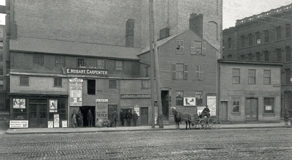
The folks at the Boston City Archives wonder if you can place this photo. See it larger.
Neighborhoods:
Topics:
Ad:
Support Universal Hub
Help keep Universal Hub going. If you like what we're up to and want to help out, please consider a (completely non-deductible) contribution.
Comments
Southie by the power plant?
Southie by the power plant?
I feel like I have gotten hockey skates sharpened in that building, tho I am sure it is no longer standing.
The Answer
Thanks for playing, folks! This photo shows 463 Atlantic Avenue, which is close to Oliver Street. We don't have an exact date for this photo, but we know that it was taken prior to 1895, likely between 1890 and 1895.
A guess: Washington Street in the South End, before the El
Two of the signboards advertise two nearby theatres, the Columbia (which was on Washington Street around today's Herald Street) and the Globe (now Empire Garden restaurant further up Washington). The third signboard is for the Old Howard which is not so close by, so I could be really wrong here.
somewhere near Atlantic Ave.
somewhere near Atlantic Ave. about 1899
According to Historic New
According to Historic New England, it's Atlantic Ave. between Oliver St. and Cotton Place
But neither the Globe nor the Columbia were on Atlantic Ave.
The caption says these are the Globe and Columbia theatre entrances, but I don't think that's correct. These are just advertising signs for the three theatres.
Agreed. This doesn't add up.
Agreed. This doesn't add up.
Cotton Place
Cotton Place was one of numerous smaller streets, and even some larger ones, that were wiped out over the past century.
http://www.wardmaps.com/viewasset.php?aid=7191
I'm guessing that's the Old Howard...
...behind the buildings in the foreground. Looks like sign above the "E. Hobart, Carpenter" sign indicates that the entrance is on Court Street. So, I'm guessing this scene is long gone, in the area around Government Center.
Atlantic Ave closer to
Atlantic Ave closer to financial district vs north end.
Definitely Atlantic Ave.
The street sign mounted on the wooden building at far right reads "Atlantic Ave."
The signs are clearly advertising for theatres in other parts of the city. The theatres mentioned on the signs weren't anywhere near each other, so these have to be ads.
Two of the theatre ads refer to Monday, November 2, which would place the year as 1891 or 1896. The next possible year after that would have been 1903, but by then the Atlantic Avenue Elevated had been built, so this photo was before that.
I don't see any overhead wires for the trolley tracks so I'll go with 1891. By 1896 virtually the entire transit system had been electrified, save for a few streets in the Back Bay and Brattle Street in Cambridge.
(There are at least three, possibly four, tracks in the street; some of those would have been for the Union Freight Rail Road, which was never electrified, but some of them would have been for the transit system, at that time known as the West End Street Railway Co.)
Here's the view today, courtesy Google Street View: https://goo.gl/maps/KjwT5944m2q
Those brick buildings in the Google image appear to have been built between 1891 and 1902.
You can read that?
No matter how much I blow up the photo, I can't read "Monday, November 2" or "Atlantic Avenue".
Use the link above to another
Use the link above to another copy of the image.
http://www.historicnewengland.org/collections-archives-exhibitions/colle...
Herald and Washington Streets
Herald and Washington Streets, Boston, MA