Hey, there! Log in / Register

BPL site lets you see how Boston streets have changed since the Civil War
By adamg on Mon, 01/20/2020 - 9:48am
You can use a slider to see Scollay Square change into Government Center.
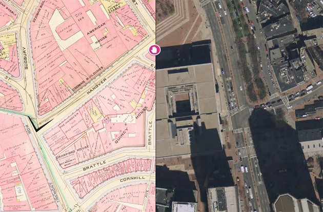
The BPL's Norman Leventhal Map Center has created this really nifty thing that you should probably stop reading about right now unless you have some free time, because you're going to want to play with it right away: Atlascope Boston lets you enter a Boston-area address (their maps don't stop at the city line) or location and then see what it looked like in the good old days (some of the maps date to the 1860s).
By default, you'll get a sort of magnifying glass centered on the address or location you choose - which you can move around to see nearby locations.
You can switch to slider controls to see the location change over time - and you can set your own "base" map - you start with a current street map, but can switch to aerial photographs or one of the old atlas maps, which lets you compare how an area looked in two different time periods. For example, in the view below, you can see the South Station area in 1938 (in the circle) and what it looked like in 1888 - note that the location of the tracks is completely different - and that they terminated at a different station:

If you want to learn more, the BPL is holding a session on using the site on Feb. 3 at the Jamaica Plain branch library (it'll be focused on JP locations, but the site's "Search Places" control will let you explore the rest of the Boston area).
Neighborhoods:
Topics:
Free tagging:
Ad:
Support Universal Hub
Help keep Universal Hub going. If you like what we're up to and want to help out, please consider a (completely non-deductible) contribution.
Comments
This is awesome
Guessing some of my model RR friends will have a field day w this. :-)
Thanks Adam.
Model RR
Exactly! Especially those of us who are building a locally inspired layout.
Ho-Hum. Nothing great
This Sanborn comparison has been done to death nationwide. Boston is just catching up. And unfortunately these Sanborn comparisons just conjure up nostalgia for a squeaky clean time that never actually existed. Neo-traditional designers forget to mention the disease, pollution, crime, rats, child labor, and industrial accidents during the Boston Sanborn era. The maps don't tell the whole story
Perhaps
Just finished reading a great book called The Devil in the White City about a serial killer during the Chicago World's Fair in 1893 (true story about a gentleman born in Gilmanton, NH and went on to be one of the first recorded instances of serial murder in the US. You definitely get a feel for the horrible conditions. But - these dioramas look great in 1/87th or 1/160th scale where you can't see the rats and the smallpox and the blood and gore oozing from little plastic people (although you could model some of that too if you chose).
H H Holmes
It was H H Holmes wasn't it
Yes
Indeed. The monster.
Pretty bad guy, possibly the worst, but very good at covering his tracks.
Pretty cool
I can finally see which families were responsible for making a total disaster of the land rights in my neighborhood. If not for a few of these families parsing up their land through inheritance in very stupid ways, we might actually have some serviceable housing density in this part of Brighton...
Huh?
Are you faulting them for not taking into account societal needs of 2020 when they subdivided in the 1800s?
Really, had the natives not been accommodating and susceptible to European illnesses we wouldn't have any of these problems. Or maybe Europeans should have have just avoided ships entirely. /S
The message from this awesome atlas project is that things change. And, private ownership/development is the driving force. In 100 years Boston will look different with land uses we can't envision today.
Fault
Their fault is to take narrow long areas and make even smaller long narrow chunks out of it. Then putting a road down the middle and then not connecting to the crossing road and then...
There are chunks that exist to today that just aren't in a shape that can support a house. Or roads that dead end for no reason.
Anyone who approved the changes could have taken a step back and said "wait, let's consider doing something better". And you're right. We don't do it today either. It's a crime we continue to perpetrate against our grandchildren.
RE:Huh?
The map project is awesome, agreed.
Disagree about private ownership/development as positive drivers of change. Do you really think the current development trend is sustainable? Traffic density is already unmanageable, for one. Affordability? No real market solution on the horizon. And in 100 years, do you not think most of Boston will not be under 6 ft of water, that is if there is any human civilization left?
Private enterprise will not "develop" our way out of climate disaster. We'll need all hands on deck to even mitigate the damage. I just don't see the private sector caring until their properties are awash, and then it will be too late.
How could you explain to people in the mid 19th century that
People in the early 21st century would be begging for free stuff on the internet? All the while insisting they were somehow entitled. They wouldn't understand any of that.
Plenty of density in Brighton
There is a big variety of residential structures, ranging from the apartment blocks along Commonwealth Avenue to one, two and three family homes in Oak Square. Not every bit of land needs scores of units. The area developed due in large part to the extension of Comm. Ave. and the streetcar line to the Cleveland Circle reservoir, and a network of streetcars that covered the neighborhood.
How does this compare to
How does this compare to Mapjunction.com?
Initial Testing
This seems to have not quite as many maps to choose from, at least for my part of Hyde Park, but it does a better job of knowing what areas are actually covered by a map, as opposed to "if you printed out a paper copy of the map and laid it over another map, the location in question would be literally covered by the margin."
This also has the cool radius mode, but the opacity of "wipe" mode isn't as easy to control, as far as I can see.
Map junction flaws
One of the very serious flaws with mapjunction.com is the lack of any connection or reference to the original maps. If you ever have the need to look at the original document, you're out of luck with mapjunction. Atlascope does a great job linking to the original sources. Atlascope is a much better tool for people who are serious about map research.
map junction comparison
Hi! Librarian at the Map Center here!
We are continuously adding more and more maps to this app, so stay tuned! Currently in the process of adding a whole new batch of 40 + more atlases, with future plans for even more to come after that!
Thanks Carl, for pointing out the important connection back to the original maps. One of the main goals of this project was to improve something like Map Junction by not only providing access to the geospatial imagery, but also tying back & maintaining provenance to the original library items.
Try clicking "About this Map". Here you can you find the volume-level record in our online catalog and the plate-level TIFFs in our digital collections (free to download)
Not only does Atlascope point back to our traditional library search tools, it also looks ahead to future projects! By clicking "About this Map" anyone can grab a link to that book's mosaic and bring it in to any GIS software or custom website as a layer.
Please do not hesitate to reach out with questions or comments! We're librarians; we love helping ;-)
Wow
Longwood Medical Area change is drastic!
So interesting
My little dead-end street in Roxbury went from "Place" to "Ave." sometime between 1884-1890. I never understood why it would ever be called an Avenue, it's a short, narrow dead-end street with 7 houses on it. I assumed the odd name change was more recent.
I never knew
The street I grew up on was once called Monument St. Looks like it changed between 1874-84
I always thought our house was one of the oldest as well, but it was one of the last that went in.
There is a book called: A
There is a book called: A Record of the Streets, Alleys, Places, Etc. in the City of Boston. Created by the Record of Streets, Street Laying-Out Department in 1902. There are a few other editions (including one in the 70s) that should answer when the change was made.
This is AMAZING!
What a fantastic melding of technology and old images. Just wonderful!
Very enlightening!
My Street did not exist back in 1898 and there was a Harlem Street in Mattapan back then with just tracts of land. I wonder when they changed the name to Clarkwood Street and built all the triple deckers that line it? They fit pretty well with the 1898 property lines so I bet it wasn't long after 1900. This is truly a fascinating project.
The 1960s make me cry so much
The 1960s make me cry so much...
I have been doing a deep dive into genealogy...
...and this is a great tool for seeing where great-grandparents and older lived in & around the city. I had been considering visiting addresses I had discovered and taking a pic of the house or apartment building.This will simplify things, since just a cursory search shows two dwellings on Saratoga Street in East Boston no longer exist.