Hey, there! Log in / Register

Before they tore down all the Boston el lines, they had to put them up first
By adamg on Wed, 01/29/2020 - 9:45am
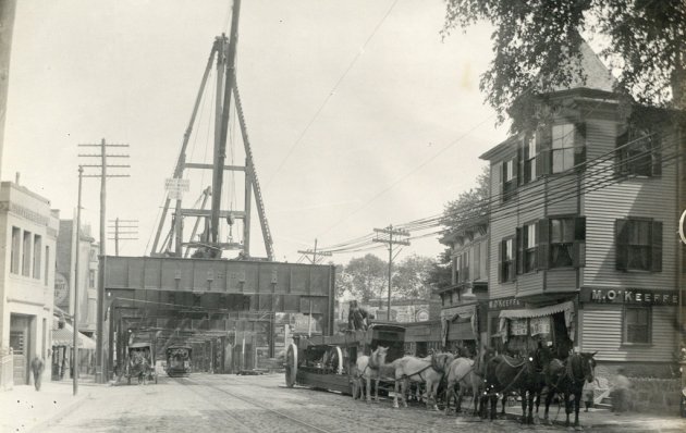

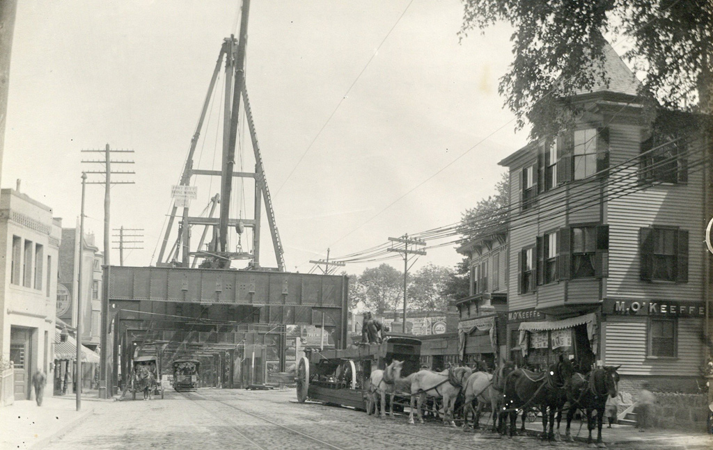
The folks at the Boston City Archives wonder if you can figure out which el this was and when (the smaller photo shows the sign on the construction rig).
Neighborhoods:
Topics:
Ad:
Support Universal Hub
Help keep Universal Hub going. If you like what we're up to and want to help out, please consider a (completely non-deductible) contribution.
Comments
O'Keefe's on the right.
O'Keefe's on the right.
If that's O'Keefe's store, it appears to be a rare alternate-timeline photo that shows elevated RR being built in the Murry's hometown before Charles Wallace and Gaudior change the timeline to avert a nuclear war.
There are two "F"s
in the name on the store.
don't know if it changes
don't know if it changes anything, but the sign actually says O'Keeffe with two Fs.
Washington St?
In Jamaica Plain?
Northampton??
After searching and digging to find out about the store on the right. The only location that came up was in the south end. There’s a gas station in the back that is probably the one on Mass Ave... or it could be further down at egleston. I do know that this is not fields corner where the store originally started.
Pittsburg
Was only the "correct" spelling of Pittsburgh, PA for a short time at the turn of the 20th century when the Post Office was trying to standardize.
If I were to guess..
I am thinking it's the Boston Elevated Railway and future Orange Line somewhere between Egleston Square and Dudley Station.
Egleston?
Looks like a firehouse on the far left. I'm guessing it's Engine 42 and we're just south of Egleston Square, looking north towards the square.
Okay, somewhat more seriously
Okay, somewhat more seriously than earlier (and leaving L'Engle out of it...)
M. O'Keeffe was a neighborhood grocer that became a small chain and eventually became First National. I found references to one store being Fields Corner - Dot Ave & Charles St - and another in JP, maybe near Centre St and Seaverns. Anybody have a reference for other locations that might better fit the elevated RR clue?
Also, second building on the left has a wall ad that I think might say Shawmut.
whoops, forgot links
whoops, forgot links
https://books.google.com/books?id=ga0W2ZL0KcsC&pg=PA84&lpg=PA84&dq=M+O%27Keeffe+grocery+Boston&source=bl&ots=E-AnbWwjmd&sig=ACfU3U0TqYelHsWd-3Vwl2-ysXn0lplizw&hl=en&sa=X&ved=2ahUKEwjz_OCF3qnnAhWblXIEHQCQCrsQ6AEwAHoECAkQAQ#v=onepage&q=M%20O'Keeffe%20grocery%20Boston&f=false
https://www.jphs.org/people/2005/4/14/oral-history-david-a-mittell.html
The Answer
Thanks for playing, folks! This photo was taken at Washington and Atherton Streets on August 30, 1906. It shows the construction of the Dudley St to Forest Hills Elevated rail.
Well done to all of those
Well done to all of those homing in on Egleston Square!