Hey, there! Log in / Register

City, feds ponder next steps for protecting Boston from rising seas, including Providence-like flood barriers
By adamg on Tue, 02/21/2023 - 2:46pm
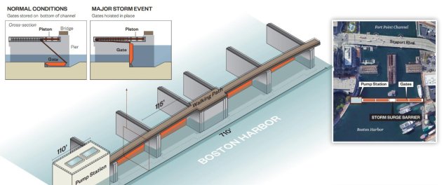
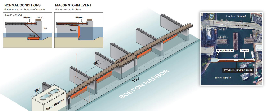
Possibility for a Fort Point Channel barrier. See it larger.
A consultant hired by the Boston Water and Sewer Commission is recommending a new barrier system where Boston Harbor meets Fort Point Channel, to keep rising sea levels and more intense storms from letting the ocean reclaim what was once South Bay - a large swath of Dorchester, South Boston and Roxbury.
Separately, the Army Corps of Engineers, which last fall released a $52-billion plan to protect New York City from rising seas, said this month it's begun to look at how to protect Boston as well - focusing on East Boston, Charlestown, the North End, Downtown, South Boston and Dorchester.
The proposed Fort Point Channel barrier, topped by a new pedestrian bridge, would have gates that would be raised as a storm approached and could cost between $459 million and $767 million, depending on configuration, the BWSC consultant, Hazen says, in a report released earlier this month.
It's expensive, but could help protect billions of dollars worth of buildings and infrastructure from the effects of climate change on our coastal city, the consultant says.
BWSC hired Hazen to look at a particular problem Boston could suffer during the more intense storms predicted over the next few decades: Many of the storm sewers that now drain Boston, which rely on gravity, could stop working and become flood generators themselves when the level of salt water rises above the height of the sewers. Once that happens, rainwater with nowhere to go could begin to burst out of the storm sewers further inland - Hazen's report estimates a third of Boston could be at risk from this sort of flooding.
The report studied 37 storm-sewer outfalls, covering about 71% of the city, and concluded that many would need moveable barriers installed over their outflows to keep surging seas out of them, for a total cost of about $568 million.
In addition to a larger system at Fort Point Channel, the consultant also recommended storm-surge barriers in the area along Dorchester Bay.
In several locations, the firm recommended that gates be coupled with holding tanks and pumps to collect water from the storm sewers - and new, higher outfall pipes to get the water into the harbor. For example, it proposed building a large tank under the grass between the arbor and the harbor in Christopher Columbus Park, along with a small building to house an electrical - rather than diesel - generator and a berm along the water. A similar setup was proposed for Logan Airport, which, like South Bay, largely sits on reclaimed land at sea level.
The Army Corps of Engineers, one of whose last major Boston-area project was to buy up several thousand acres of land along the Charles River to act as sort of giant natural sponges to soak up spring floodwater, announced its plans to look toward the sea in a Feb. 3 meeting with city officials already studying ways to minimize the effects of flooding from a combination of rising seas and more intense storms.
The Corps estimated that more than 18,000 buildings and structures in the city's harbor-facing neighborhoods could be at risk.
The Corps says it will spend the next two years working with the city and residents to figure out the specific risks to different areas and how best to prepare for them and then release a specific plan in 2026 for Congress to consider funding.
Though its Climate Ready program, Boston has already begun work on a series of short- and long-term proposals for handling storm surges.
Martin's Park, on Fort Point Channel, for example, is designed to act as a reservoir after heavy flooding and storms. Moakley Park in South Boston is being redesigned to act the same way. The BPDA last week authorized spending $880,000 to study what can be done with Long Wharf to keep the harbor from roaring in along it into downtown Boston.
The Corps's plan for New York calls for construction of a massive series of storm-surge gates and seawalls to try to prevent a recurrence of Hurricane Sandy's destruction.
Eric Bender has more on protecting Boston - and the history of the harbor.
Ad:
Support Universal Hub
Help keep Universal Hub going. If you like what we're up to and want to help out, please consider a (completely non-deductible) contribution.
Comments
New Bedford also has a hurricane barrier
New Bedford is up a river
So is Providence.
So is NYC.
I can understand why a city that didn't seem to have a problem with building on vulnerable flood lands would think that building is the answer - especially given the influence of massive project corporations. But the state will not likely allow Boston to do anything that will dump the problem on other communities, suck dry adaptation funds for the entire state, or involve further destruction of marine systems that are adaptive.
At least this addresses a localized issue within Boston - but to protect a number of things that should have been built to flood like the ICA was.
NYC is not up a river
Most of the west side of Manhattan is on the Hudson River, but lower Manhattan is on a bay and the east side of Manhattan is on an estuary (the East River, which isn't a river) connecting that bay with Long Island Sound. All five boroughs have parts that are on bays, LI Sound, and/or the Atlantic Ocean.
https://commons.wikimedia.org/wiki/File:Waterways_New_York_City_Map_Juli...
True
Its in a fjord.
But there is still a narrows that can be far more easily bridged than anything that we have.
If you only care about Manhattan, maybe
People in the outer boroughs think they count, too.
And, again, lower Manhattan is on a bay, a river, and an estuary - see the map I linked to. There's not just one waterway that needs to be blocked, the way there is for Providence.
What about the Back Bay,
What about the Back Bay, which is all fill? Is there any plan for that?
Already protected
Scroll through the BWSC report and it says Back Bay, etc., are protected by the Charles River Dam, which is both a physical barrier and has some big pumps to keep the Charles River Basin at roughly the same level even during a big storm.
Plus, all the thousands of acres of land the Army Corps bought and just lets sit there between Medfield and the Basin help by soaking up lots and lots of rainwater (you can get a great view of this in action from the top of Millennium Park, where you can see the large marshes along the Charles, mostly looking marshy, except after winters with a lot of snow, when they sort of become large lakes, full of water that will not immediately flow downstream).
Thinking too small
New York is in the right mindset.
We need to do something much bigger than this between Deer Island and Hull.
The Atlantic Ocean is going to get much taller - quick like - and we are woefully incapable of pondering the first $20 billion property damage bill or the inevitable multi-billions of damage to follow. It doesn't surprise me that we're not thinking about long-term disaster mitigation.
The problem with that is that
The problem with that is that there are multiple rivers that dump into the harbor. A high tide plus excessive rainfall would make the system useless as the rivers would backfill into the harbor and negate keeping the ocean out.
It would open and close with the tides
I saw something about how a barrier like that would operate where it would close as low tide ends which would leave plenty of space in the harbor to hold the water coming out of the rivers without risk of flooding for the hours while the higher tides & surges are kept outside. Then when the tide is going out and the sea level is lower than the harbor it opens again to bring the level back down before the next surge.
Who is "we"
And where does the money come from?
Coastal areas are not the only areas grappling with climate impacts - but, yeah, sure lets blow the whole load on massive construction projects with a global history of massive delays and cost overruns and just pretend that other parts of the state and country don't exist.
"pretend that other parts of the state and country don't exist"
Are you just figuring that out?
/s
The money comes from the state/country
and it goes to protect the areas that are economic drivers of the state/country.
Unless you're proposing we somehow pick up everything in Boston and move it 20 miles to the west (and how much will that cost?), it seems pretty reasonable to spend state money to build protections that will keep the main source of the state's income healthy and thriving.
It may come to that
It may come to that. What exactly do you think is going to happen if this proves to not work, or if it never gets off the ground, or...?
Hard to say, but
I can definitely guarantee it won't work if we're already declaring that it's pointless now.
Oh yeah, the state taking the
Oh yeah, the state taking the entire area between Marlborough, Concord, Weston, and Medfield by eminent domain (or the famously flexible and community-minded residents of the area agreeing to give it up voluntarily) so we can move dozens of skyscrapers, universities, public housing developments, and industrial facilities there definitely seems more likely to work than flood barriers or canals.
oh god
the economic engine of MA (shit, all of New England really) is Boston. Without the greater Boston area, MA is proper fucked financially. So lets cool it with the "why should [insert town west of Natick pay for Boston problems?" mentality.
I prefer the canal solution....
Remember when we were imagining that? Good times.
https://www.bbc.com/news/magazine-29761274
This is more likely to work
Quite frankly sea walls aren’t going to work. A combination of habitat building and deliberate distribution of water like this would probably work a lot better. The Dutch manage to live under water by doing pretty much exactly that.
Yes, a red-light district in Boston!
First cannabis, then canals, then a red light district to pay for the canals by taxing the woman of the night and their gentlemen callers!
There's been a movement in
There's been a movement in Amsterdam for like 50+ years now to move their red-light district out of the city center. Back Bay is pretty far away from central Amsterdam, maybe we can make a deal.
There's still time. Everyone,
There's still time. Everyone, meet at noon Sunday at the corner of Boylston and Newbury. Bring a shovel and work gloves.
No need to replace the Northern Ave Bridge
Given this plan for the barrier is to have a pedestrian walkway on the surface.
Generator?
Should this be pump, rather than generator? If a generator, what does it generate?
Tidal?
Could be tidal generation of power.
Like the area around Causeway Street was once tidal mill.
When does the Dutch Boy
When does the Dutch Boy arrive to consult?
You're joking but I've been
You're joking but I've been saying for decades that we're going to be very glad that the Dutch spent so much time figuring out this particular subspecialty of civil engineering.
Let's try canals
I refer involved and interested parties to my master's thesis work exploring canals as a flood adaptation measure for Boston: https://www.patrick-snyder.com/_files/ugd/249ac7_293e2997c3304c24ae48817...
If you believe that Mass leadership will solve this problem
Attend, watch or listen to the St. Patrick's Day breakfast. Everyone from the Boston City Council right up to the US Senate are typically there. They either were involved or were mentored by those who brought you the Big Dig.