Hey, there! Log in / Register

Interesting street light in old Boston
By adamg on Wed, 05/31/2023 - 10:33am
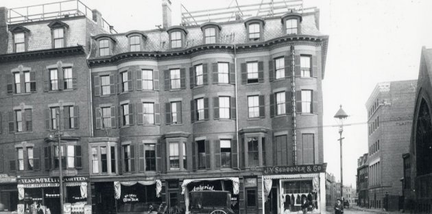
The folks at the Boston City Archives wonder if you can place this scene. See it larger.
Neighborhoods:
Topics:
Ad:
Support Universal Hub
Help keep Universal Hub going. If you like what we're up to and want to help out, please consider a (completely non-deductible) contribution.
Comments
Lay Up
Nearly every building is still there.
Yep, easy this time
Both the church and the other corner building are very noticeable and in an area of town lots of people pass by.
Google says J.Y. Schooner was
Google says J.Y. Schooner was at 6 Devonshire St.
Washington and Newcomb Streets Roxbury
Most of the residential / retail buildings are still there.
The church and the building behind it are still there too. Even the sign on the tall building on the right is still there.
Agreed
Here's the amazing part that I found. As you said, that PP Caproni building on Newcomb that you can barely read the name on is still there (and that gargoyle is still there too). It turns out Pietro Caproni built a studio there and made plaster recreations of famous sculptures so museums and universities could have replicas of the originals to study/display.
And the company is still going today and built a showroom/museum in Woburn where they still do some of the work.
The building, itself, while still displaying the name is now a set of 9 condos.
https://en.wikipedia.org/wiki/Pietro_Caproni
thanks Kaz
I have a couple of old Caproni figures and a catalogue, i had no idea the business was still around - thanks for the info!
Definitely Washington Street
Definitely Washington Street in Roxbury. I think Emmanuel House kindergarten is down the side street,
Bob Shure
I worked for him when I was fresh out of college. I liked him - nice guy.
Technically the South End
The official boundary of the Town (later City) of Roxbury was about halfway between Thorndike and Hunneman Streets. North of this boundary was the City of Boston and its South End neighborhood.
The post office gets it right; up to 1999 Washington St. in in Zip 02118 (Boston); 2000 and higher is 02119 (Roxbury)
Since the 1960s, a number of different "boundaries" between the South End and Roxbury have been proposed by the BRA, by real estate agents, and by others. When the Inner Belt was still being planned, the BRA and city moved the neighborhood limit to the center of the highway, which made some sense. With the highway never built, that would now be Melnea Cass Blvd. More recently, some people have proposed Mass. Ave. as the boundary.
But in the 19th century, when these buildings were erected, and when the photo was taken, everyone knew that the boundary was at the old city/town line.
Here are photos of the official boundary marker (dated 1823), as it looked in 1940, in front of 2000 Washington St. -- it's gone now, I'm afraid:
https://www.loc.gov/pictures/resource/hhh.ma1118.photos.076196p/
https://www.loc.gov/pictures/item/ma1118.photos.076195p/resource/
Massachusetts Avenue was the
Massachusetts Avenue was the boundary to the people who lived in Roxbury if by recently you mean the 1950s. Personally that will always be the boundary in my eyes, developers and politicians be damned.
Must have had 2 locations
6 Devonshire was right downtown next to Dock Square and on the wrong side of the block from what's pictured. The door next to it is also numbered 1904 and that suggests it's pretty far from the center of town on a longer road.
Def one of their easier puzzlies
So 1904 Washington St. Have friends on Newcomb so I recognized it right away.
I don't know whether or not that was a typo
...But I'm definitely adding "puzzlies" to my lexicon.
Schooner
J Y Schooner & Co firm had several addresses over the years. 6 Devonshire appears in permitting, 513-515 Beacon in assessments; BlueBook list residence as 32 Brookledge, Grove Hall PO, near the Franlin Park. But I have to agree with those saying this is 1900-1904 Washington
The Answer!
Thanks for playing, folks! This photo shows the east side of Washington Street at north corner Newcomb Street. It was taken on October 30, 1899. You can see a high res version of the photo here: https://cityofboston.access.preservica.com/uncategorized/IO_59cf99b5-42c...
Was wondering the date
That means the church on the side of the picture is almost brand spanking new for that photo. I was looking at the old bromley maps yesterday and I don't think the church was there in 1895 (if I'm recalling correctly).