Hey, there! Log in / Register

More parkland, paths could be coming to the banks of the Neponset in Hyde Park
By adamg on Wed, 04/19/2023 - 10:25am
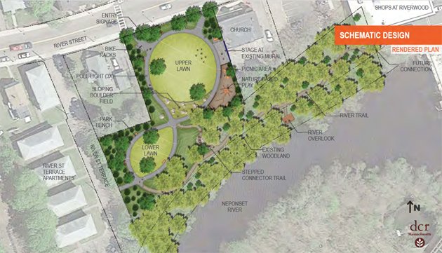
The Boston Conservation Commission this evening is scheduled to review state plans to turn what is now a large grass field and poison-ivy-infested woods along the Neponset near the Shops at Riverwood into a new park with trails, a river observation platform and a performance area.
Separately, the Metropolitan Area Planning Council and the Neponset River Watershed Association are studying the idea of connecting the Neponset Greenway path, which now ends in Readville, to the Blue Hills Reservation on the other side of Neponset Valley Parkway.
Conservation Commission approval is one of the last things the state Department of Conservation and Recreation needs before it can begin turning the former Doyle Playground off River and Rosa streets into a riverside park. The commission's hearings begin at 6 p.m. DCR plans originally called for construction to have begun last fall.
People of Hyde Park Wanting Equal Representation first began fighting to do something with the nearly one-acre parcel - which runs along the river to the old dam behind the shopping-mall property - in 2016. Through local fundraising and grants, the group and the Southwest Community Development Corp. raised enough to hire a design firm to plot out a new park, even as POWHER members were spending time cleaning up the River Street side of the parcel and erecting a river-themed mural.
DCR plans call for carving a walking trail right along the river, with an observation deck at one point. Invasive species - including the poison ivy and Norway pines will be removed and replaced with native species. Benches and picnic tables will be put in. Boulders, including the ones that now sit along River Street, will be moved to make them appear more naturally situated. The area in front of the POWHER mural will be lined with permeable paving stones, so it could be used as a performance area.
The Neponset River Watershed Association is planning a Doyle Park Day at the site on May 6 to introduce the proposal.
The site today:

Further up the Neponset, in Readville, MAPC and the river group are currently conducting a survey to gauge public interest in the possibility of creating "a continuous greenway corridor" that would link the Neponset Greenway, which now runs along the Neponset from Dorchester to Turtle Pond Parkway, to the Blue Hills Reservation, a part of which extends into Boston at Fowl Meadow, just on the other side of the parkway.
There are several greenways that exist or are planned between downtown Boston and the Blue Hills, but they don’t all create a continuous connection to the places people may want to go. We’re hoping this project can help fill a long-overdue gap in the greenway network to allow more people to access the region’s largest public park by foot, bike, or other wheeled device.
The idea of connecting Boston to the Blue Hills Reservation for bucolic rides and walks is not new. In the 1890s, Boston city planners proposed connecting the city's Emerald Necklace with the reservation via parkways, back when that still including horses in the planning. The result was West Roxbury Parkway - which passed through the state's new Stony Brook Reservation - and Neponset Valley Parkway.
Neighborhoods:
Free tagging:
Ad:
Support Universal Hub
Help keep Universal Hub going. If you like what we're up to and want to help out, please consider a (completely non-deductible) contribution.
Comments
It should extend down to
It should extend down to Neponset River Parkway.
It already is (kind of)
Going northbound, there's only that weird gap between Dana Ave and the start of the climb after the U-Haul place and the apartment buildings. I've run that route enough times to have seen the signs noting the end and reemergence of the path.
This is going south of the Neponset Valley Parkway, if I'm reading it right. It is rough going in that area. I'm guessing that are talking about a path through the woods that would involve another bridge over the Neponset linking up with the Burma Road.
Or they could be talking about that gap, which is fixable if enough money is available. Just move the curb to the outer edge of the bike lane and do some landscaping including raising the elevation of the lane to match the current sidewalk. Of course, something would have to be done about the U-Haul place, but it's doable, again assuming the funding is there.
Poison ivy
is a native species.
And ...
Native species can be considered to be invasive in some measure if they are provided with habitat that allows them to grow out of control, or if they grow out of control in environments within their historic range where they were historically absent.
https://lakes.grace.edu/native-non-native-invasive-species/
Algae is also native - and also grows out of control given certain conditions.
Some of this is semantics, though, and depends on who you are talking to and what definition they use.
Send in the Goats!
Send in the Goats! They worked a trick at the corner of Flint and Astoria Street in Mattapan. Not that it got turned into a park but it is once again safe to be used as a play area.
Pretty cool idea
Way to go guys, this is a great idea. There is also a large and recently cleared area across the river from here I wonder what will be done there. It might be in Milton and access requires you to go under a train track through what's a lowish crossing point that seems to be the limiting factor, time will tell :)