Hey, there! Log in / Register

Standing in the middle of 95 South at rush hour
By adamg on Sat, 04/14/2018 - 10:06am
It's 5:30 p.m. on a weekday on 95 south - where are all the cars?
By now, the story of why I-95 doesn't go straight through Boston is well known: Bands of determined residents helped convinced Gov. Francis Sargent we really didn't need a couple of superhighways rammed through Boston, Brookline, Cambridge and Somerville - I-95 and the I-695 "inner belt."
But before Sargent cancelled plans for the Southwest Expressway for good in 1972, the state had already taken hundreds of acres of land, demolished hundreds of houses and businesses - and actually begun work on the road.
Today, 50 years later, you can still evidence of the roads that never were, from the stub ramp off I-93 in Somerville to empty lots along Columbus Avenue. And you can, if you're out for a hike, even walk on parts of the road.
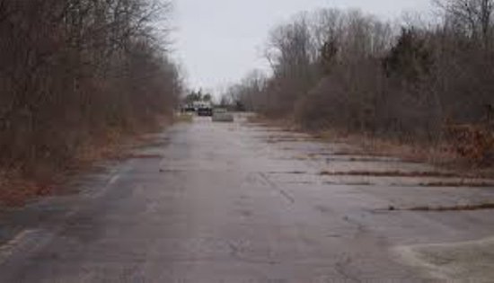
The other day, I set out for the northern half of the cloverleaf where Rte. 128 and I-95 were going to meet in Canton.
I took what might be the longest way to walk there: Drove over the Neponset at the Hyde Park/Milton line, veered right and pulled into the parking lot for the canoe launch. I followed the path sign to Fowl Meadow and then started walking. And kept walking. And walking. Until I could hear and then see the traffic on 128 (note: There's currently a fallen tree across the path near the end - you'll either need to carefully make through the large bramble or have thought to bring hip waders so you can walk through the swamp on either side of the path).
The path ends in a short paved section; follow that up, and you're at the exit ramp where traffic from 95 south would've gotten onto 128 north:

Turn to your left and you'll see the MassDOT storage shed that sits a bit further north on that ramp:

There's a path around the right of the shed that gets you back onto the ramp, which ends a few hundred feet into the woods with some dumped asphalt and logs:


At the dumped asphalt, you can get onto the main interstate, or what's left of it, heading south. It ends just past a collection of Jersey barriers - and just before 128:

If you look at a satellite view of the cloverleaf (see below), it looks like it'd be easy to get from the southbound to the northbound side - just walk through a bit of woods. What the view doesn't show, though, is the 15 or 20 foot drop in between. The cloverleaf was built in a large marshland - and had to be raised well above it. In fact, one of the objections to the highway was that it would have destroyed Fowl Meadow, which today is largely a wildlife preserve (on the way back, I saw a couple of deer). But the northbound lanes seemed equally quiet:

The ramp from 128 north to I-95 south:

Oh, look, a sign the state had to take down when it decided Rte. 1 no longer went up along the VFW Parkway (today, the exit towards that road is marked "To 1A"):

If you go, make sure the GPS on your phone is turned on - it's fun to see where you are and figure out which direction you'd be heading if the cloverleaf were actually in operation:
If you want to complete the undone I-95 circuit, head up to Revere for the northern part of the highway that never was.
Neighborhoods:
Ad:
Support Universal Hub
Help keep Universal Hub going. If you like what we're up to and want to help out, please consider a (completely non-deductible) contribution.
Comments
Hundreds of houses
You know, which humans relied on for shelter. And now it's literally (expletive) nothing.
Try to remember Gaffin's fine piece of weekend feature photojournalism today the next time you blithely suggest that any piece of private property be forcibly taken from its owner by the state for any reason.
No need at all ...
"...we really didn't need a couple of superhighways rammed through Boston."
Because it's not like we have any traffic congestion or fatalities on roads much less safe than highways (which have the lowest fatality rates of all roads), or standing room only during commuting hours on subways, buses, and commuter trains.
Suburbanite?
The highway would've been simply marvelous for suburbanites who find the subway too icky for getting into the city (the I-95 extension plans also called for continuing the Orange Line to 128). It would have destroyed whole sections of Boston, so as a Bostonian, I'm grateful for what Sargent did (plus, look up what happens when you build more highways - you wind up with more congestion).
As it was, the project did destroy a number of places in the Boston area both directly (Jackson Square) and indirectly (ever wonder about that impressive and seemingly oddly placed bank building at Rte. 9 and Harvard Street in Brookline Village? Brookline Village used to be a classic New England commercial district, where a bank like that made sense; the entire intersection was redone in anticipation of I-95).
Yes, highways are for suburbanites at all hours
To work in jobs to make cities more vibrant while increasing city tax revenues.
It also allows cities to sustain more economic activity, otherwise costs of transporting goods and housing become too expensive to justify. Housing in congested cities is just too expensive for many jobs to pay for, but driving from cheaper housing a highway drive away let's people still afford to work in the city.
And has Boston suffered because this road never opened?
Some citations needed. Ditto for New York, which finally revolted against Robert Moses. And San Francisco, which never replaced that highway that fell down in the earthquake.
All three cities have their problems, but lack of economic activity isn't one of them.
What if all the pike traffic went through the city
Actually there was a time when thT was true. Highways are terrible for the people who live next to them but they get that traffic off the streets.
It's as easy to argue that Moses made NYC and the rebels are living off his legacy at the same time as they denounce him.
Robert Moses did not make NYC
The projects he pushed through resulted in greater and greater cars coming into the city. He provided case book examples of induced demand. But he did not "make" Manhattan. Manhattan was already a major city by itself, not including the other burroughs. Manhattan leaped to the top of the art world following WW2 not because of Moses but because of factors related to WW2. Moses did not make New York as a whole a commercial center, or financial capital. The evolution toward those attributes arose from factors having nothing to do with Robert Moses.
Robert Moses rode the wave of anti-city contempt. There was a set of people who hated cities and wanted them, if not destroyed, then at least crippled. Moses destroyed neighborhoods in the Bronx. John Hines, the BHA and its successor the BRA destroyed the west end. Followers of so-called Urban Renewal destroyed neighborhood in Baltimore, nearly destroyed the first part of Baltimore settled by colonists. They saw working class neighborhoods and declared working class neighborhoods to be slums. The reality is that they wanted to destroy cities and proclaiming vast neighborhoods slums was their weapon.
By emphasizing the car is king philosophy, and assuming that urban environments are somehow evil, Moses also contributed to the 2nd class public transportation systems prevalent throughout the nation. If the anti-urban animus had not developed we would have better maintained and better developed mass transit systems throughout the nation.
Denouncing Robert Moses recognizes that he was an arrogant, nasty piece of work who was good at accumulating power but had so much hatred for city environments that he was had no ability for compassion or wisdom. I remember a statement Moses made about people not knowing what is good them. But he did.
Robert Moses did make some truly beneficial contributions. The concept of the parkway is one. Robert Caro, no fan of Moses, nevertheless mentions others. But on balance a terrible mistake and assault on cities were Urban Renewal along with Robert Moses and his followers found in other cities.
Nonsense
The cars didn't come because of the highways.
The cars came because people wanted to live in suburbs but still had to work in the city. The demand was "induced" alright, but it was induced exactly the opposite way of how you're claiming.
Before WW2, there were two ways to live in this country: packed nose-to-tail in cities or planted into the ground on the family farm. Mobility enabled by personal automobiles enabled a more civilized way of life than either of those two. Lots of people saw the benefit...hence lots of cars and lots of roads for them.
It's not that simple
There were a host of public policy and infrastructure decisions put into place to privilege cars, driving and the suburbs over public transportation and the city. There's a perfectly viable commuter rail stop in Foxboro - why isn't it in use? Because the town of Foxboro didn't want to make it easy for people without cars to live there. With a more extensive light rail network, the suburbs could be a lot more integrated, and less emphasis placed on single-family housing with a two-car garage. Systematic decisions were made not just to introduce suburban living, but to privilege it. There's far more than just the invisible hand at work here.
Not gonna happen
The rest of your argument has merit, but this statement is just plain wrong. You cannot live in a town like Foxboro without a car. Just because you can commute into Boston doesn't mean living without a car is possible, or desirable.
I dunno
Look at the hundreds of houses walking distance from Foxboro Station. And by hundreds of houses, I mean the large parking lot, shopping center, and 68,000 seat stadium.
Of course, we can also ignore the fact that the biggest opposition to using this spur on a regular basis has come from Dorchester and Mattapan for some reason.
More to life
I don't know about you, but my life consists of more than commuting to and from work. Foxboro simply doesn't offer much in the way of entertainment and necessities for someone without a car. You know - living.
Saying that, I'm not familiar with this battle over the rail line. I would think an existing rail line would be used to its potential, but then politics gets involved....
Induced demand
It is a thing. A SCIENTIFIC thing.
Here's a rundown of the SCIENCE in lay language, since you are clearly a neophite. https://www.wired.com/2014/06/wuwt-traffic-induced-demand/
Go look it up. And provide some references for your assertions. Yelling into space is not "scientific". It is stupid.
You know just enough to be dangerous
You can keep reciting "induced demand" like it's a benediction against the devil all you want, but you can't wish away the fact that it's not applicable to Boston road network since it's already over capacity and already has no redundancy. I say again: lane diets and induced demand only hold in some circumstances. It's not a universal truth. If it were, the optimal way to get people from A to B would be to have no roads at all.
But then, again,
After WW2, when it became fashionable to move from the city to the suburbs, due to a desire for a house, with both a front yard and a back yard for their kids to play in, better schools, safer streets and parks, and more open green space, many people did precisely that.
Also, much of the migration to the suburbs was due to people's fears of being inundated by non-whites, as well.
In exchange for living in urban areas, however, the people who moved to the suburbs had mortgages and long commutes to and from the city for work, and huge traffic jams to contend with.
Ahem
San Francisco and New York turned their highways into surface streets with intersections. They didn't remove the roads entirely, they just slowed them down.
Oh, about SF
They didn't just put in a surface road. They also put in a new trolley line - and stocked it with old cars from other cities, including Boston.
But if you're unable to tell the difference between a surface road and a freeway, there's not much to discuss, I guess.
Ahem
Portland, OR ripped down a goddamn freeway and made it into a river front park.
https://gizmodo.com/6-freeway-removals-that-changed-their-cities-forever...
It isn't the only place to have done so successfully in the last 30 years.
Cities are for people. Not for cars. Don't like it? Roam freely around your suburb. Nobody cares.
San Francisco and New York
ummm.....
When did NYC last turn a highway into something else?
They tore down the connections to the Richmond Parkway on Staten Island 10 or 20 years ago - a parkway that they never finished building in the first place and had ramps to nowhere at its planned interchanges with the West Shore Expressway and Staten Island Expressway for 30 years at least. I don't know for sure, but I don't think they put any road there.
They turned part of the elevated West Side Highway in Manhattan (from somewhere around the cruise ship terminal all the way south to the Battery) and turned it into a surface road with intersections - Yes.
35 or 40 years ago.
Because it was falling down
A bit more to the West Side Highway story
The highway wasn't falling down, it literally fell down one day - a truck fell right through to the surface (a couple blocks away from my father's office, so, yeah, I remember it).
The city initially planned to replace it with a brand-new, sparkling superhighway called Westway - and the feds committed to paying like $2 billion But a judge basically ruled against it and the city got the feds to give them most of the money for subway work - hmm, now where did they get that idea? The rest went to replacing the old elevated highway with, yes, a surface road.
Yes, I remember the collapse
Yes, I remember the collapse, and WestWay.
Still, that was 40 years ago, and because of the one collapsing and the judge.
The question remains - what have they done anywhere in that city in the intervening 40 years in the category of replacing a highway with a surface road & at-grade intersections, etc...?
A benefit of both ...
... the tear downs and the abandoned project is the Berkeley Community Garden which sprang up in a long block of razed brownstones along East Berkeley Street between Shawmut and Tremont . Much preferable to a highway ramp.
There's also a community garden in Roslindale
Off Cummins Highway, on land that was going to be part of the I-95/Cummins Highway interchange. It's a very nice community garden, and it's always nice to see what's growing there - but never forget that like two entire blocks of homes were bulldozed to make way for an interchange that never got built.
Yes, Boston has suffered because the road never opened
http://fortune.com/2018/02/06/most-congested-cities-worst-traffic/
LA has the worst traffic because highways promote business and people with jobs. NYC is second despite having the most public transit in the US by far, and more than most other global cities.
San Francisco, despite a much smaller metro size than many US cities, rose to third in the US thanks to its constant efforts to remove street travel lanes after not rebuilding elevated highway following the earthquake. Bike lanes didn't do shit for congestion except make it worse.
SF, 3rd most congested US city, but only 4M metro residents. Dallas, 10th but 7M metro residents. Houston 6M metro residents and not in top 10.
Fact: removing roadway worsens congestion. Building roadways supports more business and residents with less congestion.
Those wonderful European cities are on the list because they lack modern highways through them, relying on small roads unable to accommodate transportation needs.
Everything you post is dumb
Everything you post is dumb and wrong. Who the hell would choose to live in Houston over a real city? There are so many studies that refute everything you say. Highways in cities is the dumbest idea ever. Designing cities for lazy, greedy suburban blobs is so dated.
Anon cited a source
Dumb as you might think it is, unless you have some other survey, calling it wrong betrays the blindness caused by your biases.
Lots of people would choose Houston
Lots more than Boston, in fact.
Even in Boston, lots more people choose to live in the suburbs. That's why the traffic is so bad. Duh.
Bye
Plenty of "fixeruppers" in the area now!
All thanks to "thoughtful development for the people".
LOL
Ahem
Really?
Because they just lost a whole lot of poorly planned development to an utter lack of planning for flooding.
Seems to me that it would be one of the absolutely stupidest places to live given recent history and highly probable future events.
Where do you live, Roman?
Lets demolish it for a highway to make things more convenient for people who do not live there.
I'm sure you would be all for that.
Pay me what it's worth and I'm gone
I'm not some blood-and-soil zealot when it comes to my house, and I don't believe in the power of one asshole to veto necessary regional infrastructure.
That's true enough, Roman
but plenty of people are moving back into the city, as well.
Lazy, greedy blobs?
And a big FUCK YOU to you, too
anon,
have you ever been to a European city? Have you ever ridden on European public transport or used a bike? Then you would understand how it is that they don’t need inner city highways and why many European city dwellers have such a short commute some go home for lunch.
I have. Many times.
They can do that because they're packed much more closely together than we are here. China too. I don't particularly care for that lifestyle and neither do the majority of Americans who choose not to live that way.
Chinese trains aren't packed....
https://www.youtube.com/watch?v=svhICTS1QXI
Part of the reason they are packed so closely...
is that they didn't tear down so many blocks too build highways and parking.
Problems of really severe congestion.
Many European cities have a really severe congestion problem, however.
Actually, that was Oakland,
Actually, that was Oakland, not San Francisco and it was rebuilt.
Actually
People who start sentences with "Actually" should maybe check with Google first. Because, actually, in this case, it was San Francisco I was referring to.
Suburbanites
I’d feel more welcoming towards the suburbanites if they weren’t hanging out on the streets and in Winthrop Square sucking on their cigarettes and throwing the butts on the ground as if Boston was just an ashtray.
Gee, why would anyone move to the suburbs
when pleasant folks like you populate the cities?
Serious question
Why do you assume these people live in the suburbs?
Those are the bike messengers
Those are the bike messengers in Winthrop square, and they're not cigarette butts, they'e roaches dude. Lighten up bro.
Here's the problem, however:
Even though the housing out in the 'burbs or the 'boonies here in the Boston area may be a little cheaper in some areas, there are suburbs and/or rural areas here in the Boston area that are just as expensive, if not more expensive, than housing in the urban areas themselves.
Secondly, whether one who resides in the 'burbs or the boonies takes public transportation or drives to and from their jobs in the city, it generally balances out, first because gasoline can be rather expensive, and secondly, so can parking. Even if one takes public transportation, that, too, can be expensive, especially since the MBTA fare has been hiked up somewhat. At least, if one lives in the city and works in the city, s/he has the option of hoofing it to and from their job, or taking the MBTA train, as unstable as it is, and doesn't have to worry about getting home super-late in the evening or at night if the weather is super-awful.
Point of Parliamentary Procedure!
You mean the building that is now operated by NETA -- it's at the corner of Washington Street and Boylston Street. Harvard Street ends in Harvard Square (no, really!) where it dies into Washington Street in the heart of Brookline Village. Washington Street is the road that continues, and it in fact is the name for the portion of Rte 9 in the "Gateway East" portion, from the aforementioned bank to Huntington Ave in Boston.
'Tis true!
https://goo.gl/maps/KNTKuy1vMvP2
I have a point of order
Isn’t Brooklin Village over a mile from any proposed highway?
(Sorry for the delayed objection, btw)
Rte 9...
My understanding is that Rte 9 was going to be the highway... which runs adjacent (or through the edge) of Brookline Village.
I’ve never seen a plan like that
And I’ve seen (or read) the plan under which American Legion Highway in Roslindale was going to extend up Metropolitan Hill to meet up with Washington Street where the other parkways come together.
My gut is that Brookline Village got its style along Route 9 for the same reason Route 9 at Chestnut Hill looks like that- it was a major automobile artery, but never a limited access highway was planned.
Let's say these highways had
Let's say these highways had been built and we could bring in thousands of more cars into Boston on a daily basis. Where would they all park? Would we tear down hundreds of buildings to build parking garages? Would the surface streets even be able to handle all those cars? And this would be an improvement?!
If we want to get more people into Boston more quickly, the key to that is better transit. It doesn't require more parking spaces in the city. It doesn't require demolishing homes and tearing apart neighborhoods to plow highways through them, reducing the livability (reduced connectivity, air pollution, noise, visual pollution, etc) for people in the city for the benefit of people who live outside it. It doesn't require trying to jam even more cars onto our already congested surface streets. To even think of advocating for such a solution is pretty ignorant given how much damage past efforts have already done.
I agree 100%
I agree 100% with you buddy!! The I-95 extension on both ends of Boston in the southwestern suburbs and the north shore of lynn and saugus would have helped if completed so would the Northwest Expressway Route 3/Route 2 extension through Arlington and Cambridge. Even worse than the fact they cancelled those highways, is that they already had the land cleared of the I-95 Southwest Expressway, so all of those empty lots in places like Dorchester and Roxbury were all for not, such a waste, true we have the orange line there now as well as the commuter rail, but that meant the folks in Roxbury lost the elevated Orange Line thanks to the highway not being completed! I'm a realist, I agree that not all of the highways needed to be constructed, but some should have been finished and implemented as planned! Even the Inner Belt I-695 could have been done properly if say it were a tunnel or depressed highway. And to think some whacko's if they had their way I-93 and I-90 wouldn't have been built and extended into Boston....can you imagine Boston with not Interstate or highway access??? It's unthinkable, with progress comes pain unfortunately, imagine if all of the farmers and what not originally protested and stopped 128 from being built...this isn't suburbanite whining, it's common sense thinking, there was and still is a way to implement ;more highways and more rail service and integrate it.
Two mile walk- each way
Well done, good sir. I've been to hesitant to go up to the MassDOT area where the old traffic lanes are, but it is still a cool hike (okay, I've ran it.) You go from being in the middle of nowhere to next to a busy highway really quick.
Fowl Meadow, American Legion
Fowl Meadow, American Legion Highway, Bellvue Hill... you and I seem to share the same running routes pretty often.
Fowl Meadow is a special occasion
But American Legion is a good way to tackle Franklin Park if you don’t live in JP or Dorchester (or Roxbury for that matter). It isn’t a well used route for people on foot, but I’m glad to see people using it.
I would bet anything you hit Bellevue more often than I do. I tend to go flat over hills.
Map overlay
Forget where I found this, so I can't credit the creator, but there's a map that overlays many of the highway proposals over a real-life map.
http://mapjunction.com/VIEWER/7527
This link centers on the junction of 95 and 695 in Roxbury, but you can zoom/scroll down to see 95 all the way down to the aforementioned junction in Canton. You can also zoom/scroll up to see how 95 would have plowed through Fenway, Cambridge, and Somerville, as well as a highway extension to Route 2 through Porter Square.
What a mess it would have been.
Coincidentally
I was reading an article about the cancelled highways yesterday.
http://www.bostonstreetcars.com/bostons-cancelled-highways.html
It has another version of the cancelled highways map, and good views of areas where the centers were torn down, with a view of Brookline Village and Rt. 9 that was completely new to me.
This Hurts Just Looking At It
While all the big interchanges look brutal, there's also something especially cringe-worthy about the stretch through Cambridgeport (a largely working class neighborhood at the time) and through the middle of Central Square.
It would also have damaged Inman, Union, and Porter squares
either by carving right through them, or by being so close on the periphery as to make these places unpleasant to be in (as the Mass Pike did to some of the Newton village centers).
And little would have been lost
Instead of the hipsters and yuppies gentrifying the life out of those places slowly, the highways would have done it quickly, and the people displaced would have found plentiful, good quality, and reasonably-priced housing with reasonable commutes in the suburbs that would have been built outside of 128.
You can't look at me with a straight face and tell me that $1 million for half a shack in Cambridgeport is the result of good transportation policy when the alternative in places like Philadelphia or Nashville is so self-evident.
Or rather, you can try to tell me that it is worth it, but I won't believe you.
I'll also take this opportunity to point out that valuing cosmetic things like the little town squares blotching the map in the urban core makes just about as much sense as valuing the rivet construction on the Longfellow Bridge to such an extent that you're willing to pay hundreds of millions more and tolerate years of added delays to make sure those rivets go on where no one will ever see them.
Try to educate yourself on
Try to educate yourself on how cities work instead of choosing denial and ignorance. You even deny supply and demand and compare Nashville to booming and rich and successful as hell Cambridge! Compare the education levels, income and lifespan of Cambridge versus Nashville. Compare the home values of houses next to highways versus those in Cambridge or near a subway station.
Newsflash
A million dollars for a shack next to a subway stop is not something to be proud of, while under 500k for a proper house in a good school district a few minutes from the highway or commuter rail is.
Educate yourself on why it is that places like Cambridge can live in that bubble. It's because the rest of the country isn't like them. Very specifically...all places have about the same demand. It's Boston housing that's in short supply. That's why you have those insane housing prices. If it were like that in the rest of the country, there'd be a revolution.
Move to Nashville
Nobody is stopping you.
I have a childhood friend who moved there and loves it, and another who is still adjusting after decades in Brooklyn.
Follow your bliss! Part of the wonder and glory of America is that you can move around, and that there are different places with different values, character, and obesity levels for you to choose from.
I think you need to read up on Nashville
n/t
You have choices
One of which is to move if you don't like it here.
The other is to form organizations with like-minded people to attempt to change what you see as a horrible situation where cars aren't more important than people.
Then again, if you moved you would have to actually pay good money to privately educate your children and you might make half of what you do here. That, and you would need to drive 45 minutes each way to that less bountiful job.
Hahaha
It takes 45 minutes to get two miles here during rush hour regardless of whether you drive walk or take the T.
But only 12 miles by bike
And yet you think that cyclists don't help alleviate congestion. Tee hee.
Are you crawling on bloody stumps?
Are you crawling on bloody stumps? If it takes you 45 minutes to go two miles, you're doing it wrong.
Exactly
I'm an old lady and I still can walk 3.5 miles in an hour. Or bike 10 in city traffic.
Most of the scooters/electric wheelchairs that I see can zoom around at 5mph, easy.
No, I'm trying to avoid bloody stumps
So I refrain from darting into traffic or cutting diagonals through concrete buildings and bodies of water.
O RLY?
"Instead of the hipsters and yuppies gentrifying the life out of those places slowly, the highways would have done it quickly"
You mean like 93 gentrified Somerville & Medord?
Intrepid shoe-leather
Intrepid shoe-leather reporting, old chum, but - ...
...doing that much photography around unused road, barriers, and brush, you forgot to bring along an important prop!
Next time, come to Saugus
Some of the partially-built I-95 is in Revere but a lot more is in Saugus. Between Ballard and Bristow streets, there is a newly built stone-dust path. South of there, the path is unimproved dirt. Eventually you'll reach a drone airport.
Used to work near there a very long time ago
In the 80's, I worked very near the train station and we had a running route that went down into this area. It certainly was an eerie area to run in. No traffic, though. ;-)
SHHHHHHHHH, Adam!
You're going to blow up one of my favorite trail running spots! I chased a good sized coyote down the trail for a while on Friday.
Seriously, though, if you had gone just a little further up the southbound side, to where it ends in the woods, you could have crossed to the northbound lanes without clambering into the gully between them. Then heading south on the northbound side, just a few steps before the guardrail for the active highway ramp, a trail would have veered off to your left that would take you to Little Blue Hill and the park and ride area on 138 near the Dunkin Donuts.
Good to know!
For my next visit down there (also good to know about the trail on the other side of 128).
Based on the impressions in the mud on the trail, somebody on a horse had ridden down it fairly recently.
Information in Southwest Corridor Park
There are a number of informational displays along Southwest Corridor Park, which is on land that was taken for the project, about what the neighborhoods used to look like and how the project was stopped.
Lots of families forced out
Lots of families forced out of their homes unwillingly. Thank goodness for the families who stood up and said no. We have the orange line now and a bike/pedestrian way directly in town. Just look at how the expressway ruined the boston waterfront as well as the whole waterfront of Dorchester - the downtown got the new greenway but the dorchester waterfront is ruined. Approximately 7 miles if prime waterfront real estate.
Just say yes to public transit over highways