Hey, there! Log in / Register

Track work back in the day
By adamg on Thu, 03/23/2023 - 12:40pm
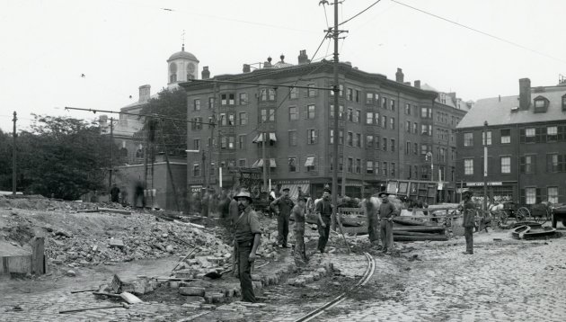
The folks at the Boston City Archives wonder if you can place this scene. See it larger.
Neighborhoods:
Topics:
Ad:
Support Universal Hub
Help keep Universal Hub going. If you like what we're up to and want to help out, please consider a (completely non-deductible) contribution.
Comments
Charles Street
Looks like the old Charles Street Jail in the background at center-left.
I think this is the current view
https://www.google.com/maps/@42.3610283,-71.0699413,3a,75y,344.68h,88.13t/data=!3m6!1e1!3m4!1sINxwfxXCAQyiVGsdFugIrQ!2e0!7i16384!8i8192
Re: I think this is the current view
If you turn around, it's adorable! as Elmer might say.
https://goo.gl/maps/HVvkyL4NZNnBue8S9
Question is when
Charles Street was progressively widened, in 1920ish when the Blue Line was built and they needed to put tracks on it to reach the Longfellow to tow trains for work, and then again in the late '20s when the Charles Station was built with Charles Circle. Can't be the latter (liquor store) and I'd guess it's from about 1910 when the bridge was first built, and that this is some sort of Cambridge Subway construction (it is the 112th anniversary of its opening today).
Looks like the Boston T
Looks like the Boston T fixing the Slow Zones in 2023 using their best equipment.
I don't think so: these
I don't think so: these people appear to be working hard and making progress.
They did something
"Check out this cool map we made! It has triangles!"
Well it's clearly somewhere
Well it's clearly somewhere north of the river, Somerville or Medford maybe, these guys are putting in the first stage of the Green Line Extension.
The Answer
Today's #mysteryphoto shows Charles Street at Cambridge Street between 1904 and 1910, likely closer to 1910. Thanks for playing, folks! http://ow.ly/1I9K50NqGiL
Right jail, wrong view
Here is the view today:
https://goo.gl/maps/fzUk2T1GGg5ZnEoz5
We're on the old bridge before the Longfellow (the West Boston Bridge) looking east into the city. Charles Street runs from left to right. That narrow "alley" to the right of the 5-story building is actually Cambridge Street running up to Scollay Square (Government Center).
The large 5-story apartment building with the liquor store is roughly where Buzzy's Roast Beef used to be, except where the street (former rotary) is now.
The row of 3-story buildings to the right are facing Charles Street. Today they would be in front of the CVS, again where traffic flows now. Actually, the building at left, with a grocery store on the first floor (note the many-paned windows) might be where the subway station is today.
Looking at the old Bromley atlases, you can see that the widening of the intersection occurred in stages.
Atlases from 1895 to 1908 show both the 5-story apartment north of Cambridge Street, and the grocery store building to the south, which is number 175 Charles Street. Even after the new "Cambridge Bridge" — later named the Longfellow — opened in 1906, all the buildings on the east side of Charles were still intact and Cambridge St. hadn't yet been widened.
When the subway tunnel and the rail connection to the bridge were built in 1912, two buildings to the south of Cambridge St. were removed, numbers 175 and 173 Charles. This is shown on the 1917 atlas. But Cambridge St. going up the hill hadn't been widened.
By the 1928 atlas, five more buildings on Charles Street — 171, 169, 167, 165, and 163 Charles — had been removed. The intersection had been further widened, and Cambridge Street widened going all the way up to Bowdoin Square — although most of the Cambridge Street widening was on the north side of the street. The 5-story apartment was still there.
The rotary, Charles Circle, was built in 1932. At that time the 5-story apartments were removed; on the south side, 5 more buildings, numbers 161-159-157-155-153 Charles were removed. Even part of the jail property was taken to build the rotary. This is also when the subway station was built; trains didn't stop at Charles until then.
In this view, I don't see any sign of the masonry work for the Longfellow Bridge, so it has to be before it was built. A temporary bridge, to the south of the current bridge, opened in October 1899, so the old bridge could be removed to make way for the new one. So I'm guessing that this photo is during construction of that temporary bridge in 1899.
A few months ago there was a similar view from this intersection, but the photographer had pivoted so the south, so that only the buildings on Charles Street were showing.
It looks so weird without the
It looks so weird without the elevated train tracks. I'd probably get hopelessly lost in Olde Tyme Boston.