Hey, there! Log in / Register

A lonely road in old Boston
By adamg on Wed, 08/23/2023 - 11:05am
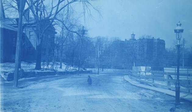
The folks at the Boston City Archives wonder if you can place this scene. See it larger.
Neighborhoods:
Topics:
Ad:
Support Universal Hub
Help keep Universal Hub going. If you like what we're up to and want to help out, please consider a (completely non-deductible) contribution.
Comments
Photo
MFA
Somewhere around the Back Bay Fens?
Perhaps Agassiz Road?
I think the back bay fens was
I think the back bay fens was a swamp land when it was created. No houses would be there.
Park Dr, Riverway, or Fenway
Those are my guesses.
I agree
The high rise in the back looks very Rivery/Fennish.
Hospital area? 1899?
Hospital area? 1899?
Not sure about the where, but when was
during Picasso's Blue Period
Cyanotypes!
The photo is blue because it's likely a cyanotype. These became more popular for photographers around the 1880s, so this photo is likely from between 1880 and 1900.
Hey kid…
…go play in traffic!
The roads at that time were
The roads at that time were safe to walk in before big gas made cars kings.
Just watch out for...
...big horse.
Horses didn’t go as fast.
Horses also had horse sense and stopped for people and objects in their way.
That looks like Longwood
That looks like Longwood Towers Apartments on Chapel St in Brookline in the background, and what could be the Muddy River and today's Green Line D alignment in the middle.
So... the foreground would be some street intersecting Riverway?
I know it isn’t ….
…. but it makes me think of Tontine Crescent.
The Answer
Thanks for playing, folks! We feel very pleased to have stumped so many of you. This is Townsend Street at Washington Street on Feb 20, 1906. The caption reads "Townsend Street at Washington Street looking towards Notre Dame Academy"
This image is from the Civil Engineer Division of the Boston Elevated Rail Company. We are in the midst of digitizing this set of photographs and will have more available for you soon!
I never would have guessed that!
Where did that magnificent building go and why?
"Urban renewal"
"Urban renewal"
Site became (most prominently) the tower you can see on the west side of Washington at that intersection (edit- today).
I guess that was the source of the name for Academy Homes?
It wouldn't be surprising if
It wouldn't be surprising if "urban renewal" was the trailing bookend of "white flight". Just possibly, I'm sayin'.
Sisters of Notre Dame de Namur founded a girls school in Boston in 1853. It moved through several sites - Lancaster Street, Berkeley Street, The Fenway (that site eventually became Emmanuel College), and Granby Street.
They founded a school in Roxbury in 1854, with elementary and boarding.
The Boston location was closed in 1954. Students were moved to Roxbury, with the boarding students moved to Tyngsboro.
The Sisters eventually built their new school in Hingham. The Roxbury location closed in 1965.
That matches what I could see on mapjunction. Atlases, planning maps, and aerials show the Notre Dame building in place until around the 60s, and definitely gone by mid-70s.
Urban Renewal
My Grandmothers Townhouse on Dayton Avenue complete with three stories, marble fireplaces, First floor dining room/ballroom with sliding dividing doors that slid into the wall and stained glass chandeliers. mudroom. large kitchen with dual sinks, 1st floor Master/Guest bedroom off the kitchen, extra long stairway to the second floor with bannister and newells.
3 bedrooms on the second floor, third floor all connected by tunnel like hallways with closets. 3 bathrooms including one in the (possibly) servants quarters on the 3rd floor, but she never had servants,and a very Large yard surrounded by large lilac bushes because it was on the corner of the street was torn down for Urban Renewal.
They replaced the entire 4 block area including the Grey LIne bus repair depot with what I believe is the largest Morgan Memorial Goodwill Industries distribution and donation center now addressed as 1010 Harrison Avenue. She got a nice little Craftsman style house on Gaston Street in trade. I'm still pissed about that but it was that or nothing.
All hail the Inner Belt.
All hail the Inner Belt.
About when did that happen,
About when did that happen, DP?
Mapjunction wasn't much help to me in this question. It had maps showing some of those streets - Dayton, Mall St - existing on paper years after aerial photos showed the Goodwill building complete.