Hey, there! Log in / Register

Time to get your saws filed
By adamg on Tue, 09/05/2023 - 10:33am
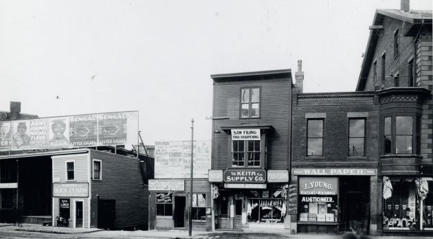
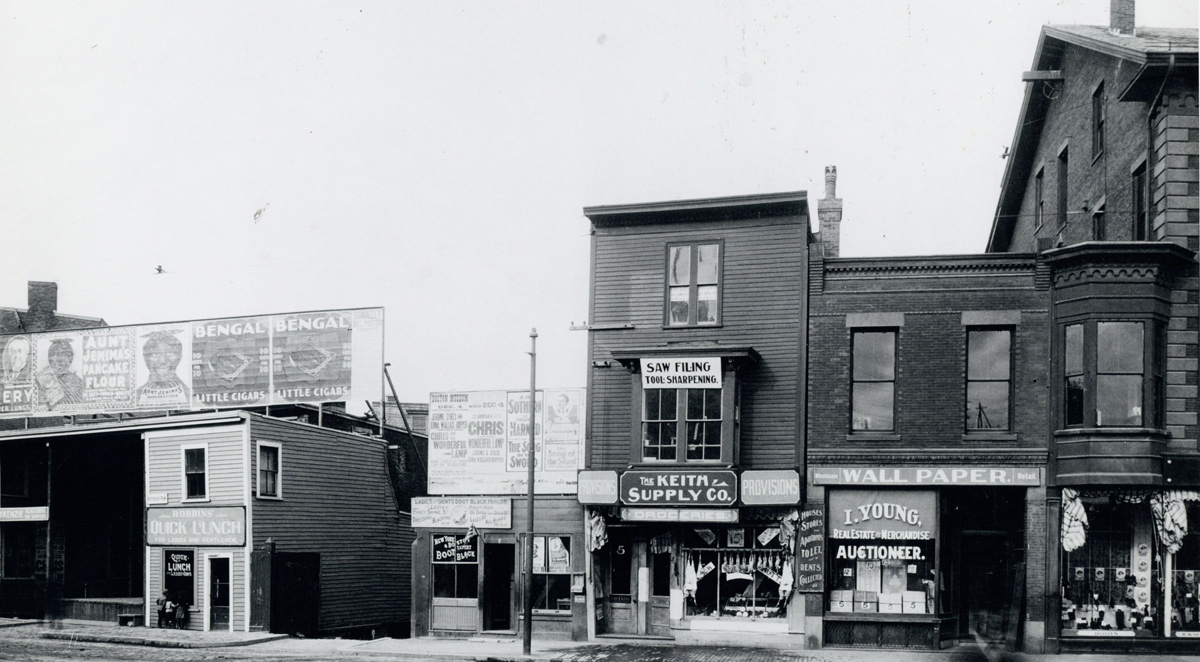
The folks at the Boston City Archives wonder if you can place this scene. See it larger.
Neighborhoods:
Topics:
Ad:
Support Universal Hub
Help keep Universal Hub going. If you like what we're up to and want to help out, please consider a (completely non-deductible) contribution.
Comments
I Think...
...it's Dorchester Avenue, looking at Dexter Street alongside Andrew Station.
A better question is
. . . who is looking out of the window above the Saw Filing sign?
What they saw will be filed.
What they saw will be filed.
Buttercup Row
Is a good name for a restaurant. Don't know if I read the sign correctly.
The name of
the restaurant is Robbin's Quick Lunch
On the awning it says "For Ladies and Gentlemen.
I suppose that includes everybody, unless there were a lot of unladylike and ungentlemanly folks around...
The kids peering in ...
Quick launch is good name for
Quick launch is good name for computer store
Good eye
That actually narrows it down to Roxbury St. From A record of the streets, alleys, places, etc. in the city of Boston (1910):
"Buttercup row, Rox.; a colloquial name for the row of wooden buildings 13 to 21 Roxbury street. "
And the date of Monday December 4 for the upcoming show gives us 1899 as the year.
Amazing detective work!
You're probably correct, but I will point out that the wallpaper building is clearly made of (or faced) with brick.
That is probably a lower
That is probably a lower number since the provisions shop is #5.
The wallpaper building is #5,
The wallpaper building is #5, so Buttercup Row presumably extends to the left but not the right in this pic.
Not a complaint ...
But we rarely see images of East Boston in this fun weekly exercise.
In the early 1900’s
the Italians in East Boston had more important things to do besides taking pictures of things.
Eh
Most of the pictures were taken by city inspectors and employees.
Boston Transit Commission
A high percentage of these photos were taken by the Boston Transit Commission (a long-defunct city agency), shortly before construction began on various transit extensions prior to World War II. The Transit Commission photos thus focus (1) on the Orange Line elevated from Sullivan to Dudley; (2) on the Atlantic Avenue Elevated; (3) on the Green Line subway and viaduct from Science Park to Kenmore, with the branch under Tremont Street running south from Boylston; (4) on the Red Line from Charles to Ashmont and Mattapan; and (5) on the Blue Line from Bowdoin to Maverick.
East Boston gets left out of the photo sets, just as it got left out of transit construction before 1940. All you have from Eastie is a few shots around Maverick Square.
Looks like...
Dudley Square to me. That hardware store was still there the last time I walked around that area. That was years ago though. I think the brick was the Boston 5 Cents Savings Bank at one point.
The Answer!
Thanks for playing, folks! Washington Street is correct. This photo shows the west side of Washington Street at Roxbury Street and was taken on December 12, 1899. This photo was taken as part of a survey of Washington Street and you can see additional images from the survey here: https://cityofboston.access.preservica.com/uncategorized/SO_0af02851-1ae...?
We hear you about East Boston. As some other commenters mentioned, most of our images were taken to document municipal infrastructure projects, and East Boston simply had fewer of those projects. We run into a similar connundrum with Brighton, West Roxbury, and Roslindale - but we will keep an eagle eye out for mystery photo candidates in those neighborhoods.
Thanks!
The hardware store is long gone but it looks like a few of the buildings are still there.
Look for 10 Roxbury Street on Google maps.