Hey, there! Log in / Register

State wants to rejigger half-done 128/95 interchange in Canton
By adamg on Fri, 01/10/2014 - 9:35am
The state Department of Transportation yesterday released a five-year capital plan that calls for spending $240 million on the interchange between Rte. 128, um, I-93 and I-95. The state says this:
Facilitates private sector investment in the University Station development in the town of Westwood.
The interchange is currently half of a cloverleaf - the other half was laid out but never built after the state canceled the proposed Southwest Expressway from 128 to the equally cancelled I-695 "Inner Loop" that started where Melnea Cass Boulevard is today.
Other proposals in the plan: Spend $1.3 billion to finish the damn Green Line Extension to Medford already, Pony up $835 million to start to buy new Red and Orange Line cars and improve tracks and signals, spend $252 million to buy new single-car diesel trains for the Fairmount Line and to extend the Silver Line to Chelsea and pay out $161 million for re-aligning the turnpike at the Allston/Cambridge tolls.
Ad:
Support Universal Hub
Help keep Universal Hub going. If you like what we're up to and want to help out, please consider a (completely non-deductible) contribution.
Comments
Facilitates Private Development?
The leases, or at least the letters of intent, are already signed for the big tenants at Westwood Station. This is a giveaway.
I am, by lifestyle choice, a suburbanite, at least until my kids are grown. I can see both sides in transportation money spending. No matter what gets rebuilt at that intersection it will still be a pooh show in the morning, when the real traffic occurs there. The new lane on 128 South to 95 South has relieved a lot of traffic in the afternoon. Any improvement, supposedly to improve traffic flow to Wegman's on a Saturday afternoon is a waste of money. People from Westwood, Dedham, Canton, and Norwood will be the primary shoppers there. They will take University Avenue in from Route 1 or Dedham Street over from Canton. They will not take 128. Only Milton people will come down 128 to Westwood Station and I hope they are delayed.
Please oh please Mass DOT, get your head out of yer arses, stop giving money to PA Landers, SPS, and all the other incredibly slow highway contractors and put the money into the new cars for the Red and Orange lines.
Nice armchair analysis.
Years of experience in traffic design and analysis are no match for some suburbanite parent who can simply intuit a complex traffic pattern and transportation network.
People doing traffic engineering for MassDOT are professionals. If you want to do their job, go for it. If you want to whine about how they're terrible at their job, hahahaha enjoy your traffic, you noncontributing zero.
Put up or shut up.
"Years of experience"
"Years of experience" are what brings about "traffic calming" projects in town centers with the intention of making them more "pedestrian friendly environments" by putting in stupid bumpouts at intersections that only serve to make sure that the main thoroughfare is almost always entirely filled with cars because people can no longer go around cars that are waiting to turn left, and meanwhile there are more empty storefronts and no more pedestrian traffic than before.
Markk, is that you with a new handle?
or are we hearing from another member of BACB (Bloggers Against Curb Bumpouts)?
Not me, just another with sense
Unlike others, I have one login and use it instead of anon, except when at some other computer without my login browser cookie. I don't have much interest in Canton, so am just getting around to reading the story now.
These capital projects have been in the works for decades, with some finally coming up for funding now. The I-95/I-93 interchange upgrade in Woburn is the busiest in the state and on the horizon for decades. It might happen later this decade. Replacing subway cars is much the same and a long process. The GLX puts money in developer pockets. We just don't know who yet because there isn't visible planning to tie the extension to big economic development projects. We've still not seen much big new residential/commercial construction for the red line extension, except at highway linked Alewife.
The state healthcare report was the big news this week. There is not enough money for transportation when Mass has the highest healthcare costs in the country and not any better health to show for it. Patrick stated that 1/3 of the state budget goes to healthcare, so between that, salaries, and disbursements, big transportation projects take several decades to happen. Even small projects like wasting money on streetscaping (with required bump outs) and travel lane removals take around a decade.
For the record, you think the
For the record, you think the Alewife extension shouldn't have been built?
Why do rapid transit extensions have to produce large scale developments? What about better serving dense neighborhoods where thousands of people already live? The Alewife stations are some of the busiest in the system. I think it's fair to say that the GLX trains will be full the day the first one rolls out of College Avenue. Why isn't that justification enough?
Alewife station was needed
The station is absolutely is a good thing and would have been better with what was originally planned - two more parking levels and a fly-over at Alewife "circle". Its the development near it that has been bad. Cambridge needed to widen Fresh Pond Parkway and Rt. 16 prior to allowing the commercial and residential construction in the area. Traffic was bad prior to 1985, and they only made it worse with cancellation of I-695 and no other smaller scale road widening. Environmentalists have also been opposed to all the added development around Alewife, though bike path construction is explicitly excluded from environmental review. The bigger problem has been to increase the flood plane further into Belmont and Arlington.
My point was that "Transit Oriented Development" is a dream, not reality. There hasn't been a building boom of new residential and office buildings in Davis and Porter squares. Porter Square got some stores though hardly exempt from significant turnover and vacancies, much like downtown crossing with its low road access. The parking lots at Porter have to be rigorously policed because transit oriented dreamers imagined no parking would be needed for subway and train users, and they have not woken up to reality that parking is needed for the GLX. I would be a supporter of the GLX if the endpoint were like Alewife, with a big parking garage and highway access. Widen congested Rt. 16 between I-93 and Rt. 2, put a big parking garage where Whole Foods is now, and viola, a whole lot more needed transportation for the area including more riders for the GLX. Unfortunately, DCR and Cambridge are in the way of transportation, as usual.
So what are the projected riders for the GLX? How many new riders initially and over time, and how many just switching from buses or the RIDE? How were these estimates calculated? How do they compare with added red line or other cities where subway replaced bus?
The key difference between success and failure of new transit stations is presence or absence of major roadway connection and parking. Alewife has it more than Porter, Davis, and all of the GLX stations, thus making it more successful and helping the whole line. I want big spending to be successful, but GLX is missing the key to success,
Porter and Davis weren't
Porter and Davis weren't supposed to have TOD because those neighborhoods were already built out. The key was building stations to serve residents already there who were either a) overloading the 77 bus and Harvard station or b) shunning transit because doing the above was a pain. And I do think Alewife is a success and useful as an endpoint park and ride station. But the reality is if you agreed that Alewife was necessary, why not build two infill stations? You were going to tunnel through there anyway.
For the record...Davis Square...with zero parking lots...mbta or otherwise...has roughly 1,000 more boardings on a weekday than Alewife, per the blue book.
As for GLX, for the sake of argument, I'll assume that every rider will either live in Somerville or West Medford and many are probably taking the bus right now. I'm not looking to bring people from Winchester or Stoneham or Woburn to ride GLX. I'm looking to eliminate the need for thousands of residents who now have to take inefficient buses through Winter Hill, Sullivan Square, and Powderhouse Square so they can reach RT stations 2 to 4 stops from downtown. We're talking the difference between a bus/RT combo vs. a one-seat ride on a grade separated light rail line. This will not only serve people in Somerville who are already on transit and some of those who don't want to deal with it now and if not them, the generation after them who will move into the neighborhood because of that access.
Davis has more public parking than Porter
Google "Davis Square parking", and low and behold, 4 public parking lots. Next google "Porter Square parking". Zero public parking lots. With $7/day parking at Alewife, many drivers choose to park for free in Arlington and take a linked, thus discounted, bus ride to Porter or Davis instead. Alewife might get more riders if there were more parking available and cost less.
I don't think so
First of all, why should parking be subsidized and "cost less"? Special privilege for car users? It would be cheaper to just give free rides to all non-car users, at $2.50 each!
Secondly, you are obviously completely unfamiliar with the level of traffic jammage in that area on a daily basis that has been a problem since the 1990s. Stop describing your ideal commute situation when you clearly have know idea what the commute situation is now!
Third, the area tried your "cars everywhere for everybody for freeeeee" approach for years. It failed. Costly, wasteful, and heavily subsidized fails. We KNOW that cars are NOT the answer. That's why things are changing.
Davis Square public parking - maximum of 3 hours
It's all metered, and none of the meters allow parking for more than 3 hours. Those parking lots are for visitors to local businesses, not commuters who want to jump on the T.
Success is the point
If you want to maximize the value from money used to build a subway station, it should include include connection to the most popular transit mode, driving. I am familiar with Davis and Porter traffic, thus avoid going there, especially at worse times. Clearly those places need relief of unmet road capacity. Needed land acquisition is prohibitively expensive, unfortunately. Adding subway stations before roadway, only makes the land more valuable and impossible to buy for needed roadway expansion.
With linkage to the most popular transit mode (roadway), development as at Alewife becomes financially viable. Elsewhere, not so much. Parking of bicycles, cars, and motorbikes, just facilitates a health friendly mode shift to walking. I don't understand all the harping on subsidized parking. Lots of things are subsidized, including road use. Back during private ownership of roads and bridges, tolls had to be paid for use, now gas taxes are mostly used. Consider the gas taxes also being used for parking.
Even MORE armchair analysis?
You don't like bumpouts, therefore the project was a failure?
If you know so much about this, then go join MassDOT and educate them! You seem to be the genius savant that has this all figured out. Stop posting about it on the internet and go heroically solve all of our traffic problems with your detailed analysis and precise studies of traffic engineering!
SimCity
I think we have another SimCity 4 player among us...
*click*
"Create Zone.."
*click*
"High Wealth Residential"
*clicks and drags*
*click*
"Add Street.."
*click and drag*
....
"High wealth"
"High wealth"
Yeah, right. Keep dreaming.
No, the project was a failure
No, the project was a failure because the "Pedestrian Friendly Environment" generates traffic jams, fewer parking spaces, no more foot traffic than before and possibly harmed the businesses.
What project failed?
What project? What failure - and according to whom?
Any statistics on that failure - like, the storefronts you were braying about?
Mass doesn't evaluate projects afterwards
Evaluating projects to see if they lived up to claims and Powerpoint presentations has been on the low priority (un-funded) list for MAPC for years. Evaluation reports would prove extremely embarrassing for them, their agendas, how they allocate money, and expose too many lies on what they claim to be good. Knowing what would be effective uses of limited funds is a non-priority for MAPC.
You know this
How?
Or is the lack of follow up a convenient canvas upon which to sling your usual assumptions and declare them holy and truthified? Absence of evidence is proof of only a lack of data - not the initial supposition, and NOT your agenda, either.
Marky?
I knew I'd see you in this thread! Keep spinning those conspiracies about the evil road designers!
Wow, Anon (Not Verified) sensitive
I won an essay contest in 9th grade sponsored by Delta Nu Alpha, the local transportation fraternity. It was titled "How I Would Improve Boston's Transportation". At that time I decided not to be a sadist and therefore not go into road design.
All I suggested was that money, my money, be better spent on public transportation and not be spent on an interchange which was just redone and allow big money to receive a benefit for a development that was going to happen already.
But if you are a professional, take it like a man and let me say good job on the leaks and the overruns on the Big Dig. Good job on the now third year of the widening of Route 139 in marshfield. Good job on the 4 Year redo of the Rte 53 bridge in Hanover. Good job with the intersection of Ruggles and Tremont. By the way I am in traffic as I write this. Good job.
The Red and Orange Lines
The Red and Orange Lines certainly need new cars. But I cringe at the amount of money involved, and the process (restricting it to nonexistent in-state rail car factories).
At least for the Red Line, they should just buy more of the 1800 series Bombardier cars. Those are the best rail cars in the MBTA system.
The Ends Justify the Means
While I don't want to comment on whether or to what extent funding for this is a giveaway to Westwood Station, the fact of the matter is this is a project that's been necessary for the past two decades.
Sure, improving traffic flow into Wegman's on a Saturday afternoon is a poor reason to do much of anything. However, what you are either forgetting or deliberately ignoring is that traffic flow to Wegman's is, at best, a pretext, and far more likely totally irrelevant. The actual purpose of this project is to realign Interstate 95 North as it feeds into 128 North. Why would we want to do that? Well, right now, the entirety of Interstate 95's traffic is being dumped onto a cloverleaf ramp that was never, ever designed for or meant to carry an entire interstate's worth of traffic. This makes the Canton Interchange worse than even the Woburn Interchange because as much of a mess as that is, at least every part of it is actually carrying the type of traffic it was intended to carry.
Is it going to make 95 into 128 in the morning any less of a, as you put it, pooh show? Absolutely. It's still going to be bad, traffic will still be awful, but it will become far, far more tolerable - and outside of morning peak travel, the road will be far less likely to lock up compared to how it is today.
Also, bear in mind that the land we need to make this happen is both already under DOT's control and hopelessly contaminated by the already-built interchange for the road that never will be built. Whether or not we do this, absolutely nothing else can be done with this land - and because all the land is already ours, the #1 cost bloater of road projects (land acquisition) is a non-issue.
There's no good reason not to do this. It must happen.
DMUs All Over The Place - Even On Grand Junction
The map showing the MBTA's vision for 2024 shows DMU's running, at least partially, on nearly every commuter rail line:

The legend is rather fuzzy (it looks like they scanned a paper copy of the document instead of printing it directly as a PDF) but the dark blue lines apparently indicate DMU service. It's very interesting to see DMU service envisioned for the Grand Junction line through Cambridge, though I don't know how realistic that really is.
wow
I have not seen this before.. then again I wasn't looking
Gee DMU's to Chelsea, that's the first I've heard about this. I know all about the Silver Line Gateway to Chelsea (I've gone to the meetings), but no talk about DMU's.
Very interesting... Thanks for the link. Bathroom reading later..
That's because
The state just released this last night. ;)
I'm sure
but wouldn't there be hearings about this like the Silver Line Gateway? Gotta have public input before any dollars are spent...
Well, they're not building anything
They're just dropping money into DMU purchases and then running them where commuter rail service already exists. There's some exceptions (ie: Grand Junction). But I wouldn't expect those to come to fruition any time soon.
Picture of Proposed Interchange
Another document has this image of the proposed interchange (see page 26)
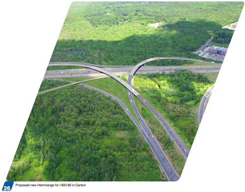
Looks like a lot of wasted space inside that ramp on right
Tighten it up and give us back some parkland, please.
Salted Earth
Hate to break it to you, but...
That parkland's gone. Kaput. Contaminated. Never to be reclaimed again. Wasted space? Absolutely. Unfortunately, it's wasted no matter what the geometry of those ramps are. Sorry, but them's the breaks.
Are you high?
No one is going to be going within half a mile of that thing besides animals. A hike through the woods right next to Interstate 95? No. Size of the ramp is pretty irrelevant.
What's with the little
What's with the little overpass coming in from the bottom left? Is that just to get to the commuter rail station? There's nothing else accessible that way with no place to cross the tracks nearby, and it already has an on-/off-ramp nearby.
Why are all of
Why are all ofthe photos and
diagrams laid
out like this?
Holy Schniekies - My West Station is on the map!!!!
Holy schniekies - my West Station is on the map!!!!
DMUs? While I've got no
DMUs? While I've got no objection to using multiple units, they really ought to be electrifying the commuter rail network instead.
Disappointing and Underwhelming
First of all, there's no "at least partially on every Commuter Rail Line" in this map. The Old Colony Lines (including Greenbush),
HaverhillReading Line, Fitchburg Line and Needham Line all have zero DMU service planned - for those of you at home keeping score, that's just about half of all Commuter Rail lines in service today. Furthermore, the NEC (Providence/Stoughton Line) only has DMU service planned for the sections of it shared with the Worcester Line, and if you're counting the Franklin Line as separate from the Fairmount Line (which you should be), it has no DMU service either. Far from "at least partially on every Commuter Rail line," we're actually only seeing implementation on parts of a third of the commuter rail system - hardly universal adoption.To say nothing of the fact that each and every one of the commuter rail lines not being considered for DMU service stand to benefit immensely from its implementation:
That the MBTA and/or MassDOT is now indicating a willingness to purchase equipment it doesn't intend to be used system-wide is also indicating that their biggest objection to purchasing either electric locomotives or EMUs; that being they don't want to be responsible for equipment that will only be deployed on certain sections of the system at certain times... is no longer valid. And if they are indeed demonstrating a willingness to purchase equipment locked to certain subsections of the system, because the Providence Line utilizes the fully-electrified NEC, there's no excuse left to refuse to purchase either EMU units or at the very least electric locomotives for operation on the Providence Line runs to Providence. (Neither T.F. Green nor Wickford Junction weren't electrified, but the overwhelming majority of runs don't continue south of Providence anyway.) Naturally, nothing in this five-year investment plan from what I can tell even pays lip service to considering a study on how much it would actually cost to do so; never mind actually going out and purchasing the equipment.
And since we're already on the topic of what isn't being done by the relevant parties, let's talk about some of the other glaring omissions from this 'Vision for the MBTA in 2024:'
All and all, I think the subject line of this comment says it best. This five year capital plan? Disappointing and Underwhelming. I expected more. I expected better. I guess that makes me the real fool here, for hoping that the MBTA would rise to the level we all need them to be at. Ha!
Unless the really long range
Unless the really long range plan is to add more stops to the Grand Junction line, that seems like a huge waste with one stop spitting distance from Kendall and West Station being served by both the Commuter Rail and another DMU line. That's just seems stupid. I wonder what the reasoning is. If they are running DMUs all the way to Woburn, Lynn,and Auburndale continuing all the way to Riverside, why not Needham? That would make more sense, and would allow more frequent service through Roslindale and West Roxbury, and they could extend an offshoot down the same corridor though Hyde Park, which looks like it's just sitting in nowhere land and currently gets shafted with high fares. A lot of people started going over to nearby Fairmount where they only have to pay $2.00 a trip ($70 monthly pass) instead of $5.50 ($173 monthly pass).
I see the B Line continues to stop every block. That's a relief. College students living in the city shouldn't have to actually walk very far across campus like their suburban college counterparts and make mass transit more efficient for moving the masses across the city or anything. That would be absurd. /end snark
That's not a scan to PDF, it's crappy image formatting in Word followed by crappy settings when converting it to PDF. The fuzziness is compression artifact, and the resize scaling to make it fit into the document looks off. Scroll past that to the Highway Division spreadsheets where the numbers are all willy nilly. Does anyone QC this stuff? Wow.
Page 43
If you click on the PDF to zoom in, this map is on Page 43.
Interesting idea, but
the video and written schedule above is so fuzzy-looking. How the hell will people be able to read this??