
We headed up to Allston today for some festive Allston Christmas sightseeing. Saw the usual sights (see below), but also this enigmatic structure on Linden Street. Anybody know the meaning behind it?

We headed up to Allston today for some festive Allston Christmas sightseeing. Saw the usual sights (see below), but also this enigmatic structure on Linden Street. Anybody know the meaning behind it?

Prairie Rose Clayton bids us a Merry Inman Square Christmas and a happy New Chair.

So those flash-flood warnings around 9:30 a.m. were for real. Sean Woods photographed a woman trapped by floodwaters on Spring Street by the Shaw's parking lot. Boston firefighters rushed to the scene to rescue her.
State Police shut 128 at Rte. 9 due to flooding. And cars were trapped by flood waters on Great Plain Avenue and Weston Road in Wellesley. Ed Grzyb reports:

About the only thing that could improve this coffee table would be a large leg lamp standing next to it.

Liz photographed one end of the Long Island Bridge during last night's fog.

The folks at the Boston City Archives wonder if you can fix this scene in time and place. See it larger.

Ashley Hill photographed the fog in the Financial District this morning.
It was a little brighter at street level, where Heather Parker was, but are those zombies in the foreground?
One of the more dramatic approaches into Boston is up Blue Hill Avenue or Blue Hills Parkway in Milton at night. You're driving in a somnolent, darkened suburb when you approach the Neponset River, you look up and boom, there's Mattapan Square and it's like looking into China from North Korea: A city where electricity is plentiful and everything is lit up.

Quincy Market a couple years after its opening.
Mass. Moments alerts us that today's the anniversary of the grand opening of Quincy Market, in 1826:
[O]nly two years earlier, Bostonians had derided Mayor Josiah Quincy's huge construction project — the largest public works project yet undertaken in the new nation — as "Quincy's Folly." ...

Photographynatalia took in the cliff diving off the ICA today, including one jump by Superman. Most of the divers were clad more conventionally:

On Friday evening I went to Revere Beach with a friend of mine for some Kelly's. I hadn't been to the Wonderland T Stop in a very long time so I was kind of surprised that how quickly the pedestrian bridge went up.
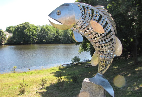
In 2012, Dedham sculptor Gints Grinbergs donated this statue, titled Largemouth Bass, to Dedham, which placed it on the banks of the Mother Brook, where Bussey intersects with Curve and Colburn.
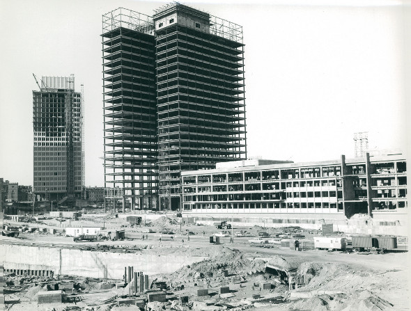
The Boston City Archives have posted a collection of photos related to the creation of Government Center in the mid-1960s, including some of the demolition of buildings in old Scollay Square. As you can see above, the JFK building went up faster than City Hall. Below, look at how you used to be able to drive right up to Faneuil Hall and Quincy Market:

Boston Harbor Beacon captured the moon coming up over the landmark lighthouse Wednesday night.
Help keep Universal Hub going. If you like what we're up to and want to help out, please consider a (completely non-deductible) contribution.


